Copyright © 2015 Bert N. Langford (Images may be subject to copyright. Please send feedback)
Welcome to Our Generation USA!
This Web Page covers
Civilization
as a complex society that is characterized by urban development, social stratification, a form of government, and symbolic systems of communication (such as writing).
See also related web pages:
Being Human
American Lifestyles
Medical Breakthroughs
Human Sexuality
Worst of Humanity
World Population
YouTube Video Human Population Through Time
by American Museum of Natural History
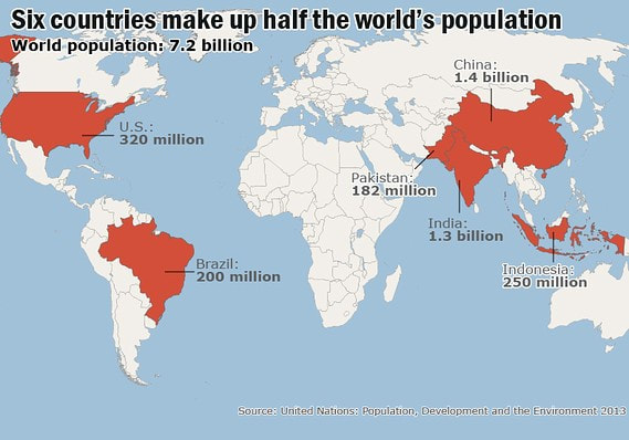
In demographics, the world population is the total number of humans currently living. As of March 2017, it was estimated at 7.49 billion. The United Nations estimates it will further increase to 11.2 billion in the year 2100.
World population has experienced continuous growth since the end of the Great Famine of 1315–17 and the Black Death in 1350, when it was near 370 million. The highest population growth rates – global population increases above 1.8% per year – occurred between 1955-1975 peaking to 2.06% between 1965-1970. The growth rate has declined to 1.18% between 2010-2015 and is projected to decline to 0.13% by the year 2100.
Total annual births were highest in the late 1980s at about 139 million, and are now expected to remain essentially constant at their 2011 level of 135 million, while deaths number 56 million per year and are expected to increase to 80 million per year by 2040. World population reached 7 billion on October 31, 2011 according to the United Nations Population Fund, and on March 12, 2012 according to the United States Census Bureau.
The median age of the world's population was estimated to be 30.1 years in 2016, with the male median age estimated to be 29.4 years and female, 30.9 years.
The 2012 UN projections show a continued increase in population in the near future with a steady decline in population growth rate; the global population is expected to reach between 8.3 and 10.9 billion by 2050.
2003 UN Population Division population projections for the year 2150 range between 3.2 and 24.8 billion. One of many independent mathematical models supports the lower estimate, while a 2014 estimate forecasts between 9.3 and 12.6 billion in 2100, and continued growth thereafter.
Some analysts have questioned the sustainability of further world population growth, highlighting the growing pressures on the environment, global food supplies, and energy resources.
Estimates on the total number of humans who have ever lived range in the order of 106 to 108 billion.
Click on any of the following blue hyperlinks for more about World Population:
- Population by region
- History including Milestones by the billions
- Global demographics
- Largest populations by country
- Most densely populated countries
- Fluctuation:
- Population growth by region
Past population
Projections
- Population growth by region
- Mathematical approximations including Years for world population to double
- Overpopulation
- See also:
- Anthropocene
- Birth control
- Coastal population growth
- Demographic transition
- Depopulation
- Doomsday argument
- Family planning
- Food security
- Megacity
- Natalism
- One-child policy
- Population boom
- Population Matters, population control think tank and campaign group
- Two-child policy
- World's largest cities
- Lists:
- List of urban areas by population
- List of population concern organizations
- List of countries by fertility rate
- List of countries by past and future population
- List of countries by population in 1900
- List of countries by population density
- List of countries by population growth rate
- Lists of organisms by population – for non-human global populations
- List of religious populations
- Historical:
The Generations of Mankind
YouTube Video Tom Brokaw discussing the "Greatest Generation"
The following photograph depicts four generations of one family: a male infant, his mother, his maternal grandmother, and one of his maternal great-grandmothers.

Generation is defined as the act of producing offspring. In kinship terminology, it is a structural term designating the parent-child relationship. It is also known as biogenesis, reproduction, or procreation in the biological sciences.
The term is also often used synonymously with cohort in social science; under this formulation the term means "people within a delineated population who experience the same significant events within a given period of time".
Generation in this sense of birth cohort, also known as a "social generation", is widely used in popular culture, and has been the basis for societal analysis. Serious analysis of generations began in the nineteenth century, emerging from an increasing awareness of the possibility of permanent social change and the idea of youthful rebellion against the established social order. Some analysts believe that a generation is one of the fundamental social categories in a society, while others view its importance as being overshadowed by other factors such as class, gender, race, education, and so on.
The Following are a List of Generations by the time as noted:
The term Generation Alpha has been suggested as name for both this cohort and for the subsequent one.
Click on any of the following blue hyperlinks for more about the Generations of Mankind:
The term is also often used synonymously with cohort in social science; under this formulation the term means "people within a delineated population who experience the same significant events within a given period of time".
Generation in this sense of birth cohort, also known as a "social generation", is widely used in popular culture, and has been the basis for societal analysis. Serious analysis of generations began in the nineteenth century, emerging from an increasing awareness of the possibility of permanent social change and the idea of youthful rebellion against the established social order. Some analysts believe that a generation is one of the fundamental social categories in a society, while others view its importance as being overshadowed by other factors such as class, gender, race, education, and so on.
The Following are a List of Generations by the time as noted:
- The Lost Generation, also known as the Generation of 1914 in Europe, is a term originating with Gertrude Stein to describe those who fought in World War I. The members of the lost generation were typically born between 1883 and 1900.
- The Greatest Generation, also known as the G.I. Generation, is the generation that includes the veterans who fought in World War II. They were born from around 1900 through 1924, coming of age during the Great Depression. Journalist Tom Brokaw dubbed this the Greatest Generation in a book of the same name.
- The Silent Generation, also known as the Lucky Few, were born from approximately 1925 until 1942. It includes some who fought in World War II, most of those who fought the Korean War and many during the Vietnam War.
- The Baby Boomers are the generation that was born following World War II, generally from 1946 up to 1964, a time that was marked by an increase in birth rates. The term "baby boomer" is sometimes used in a cultural context. Therefore, it is impossible to achieve broad consensus on a defined start and end date. The baby boom has been described variously as a "shockwave" and as "the pig in the python". In general, baby boomers are associated with a rejection or redefinition of traditional values; however, many commentators have disputed the extent of that rejection, noting the widespread continuity of values with older and younger generations. In Europe and North America boomers are widely associated with privilege, as many grew up in a time of affluence. One of the features of Boomers was that they tended to think of themselves as a special generation, very different from those that had come before them. In the 1960s, as the relatively large numbers of young people became teenagers and young adults, they, and those around them, created a very specific rhetoric around their cohort, and the change they were bringing about. This generation is also referred to as the Me Generation.
- Generation X, commonly abbreviated to Gen X, is the generation born after the Western Post–World War II baby boom. Demographers, historians and commentators use birth dates ranging from the early 1960s to the early 1980s. The term has also been used in different times and places for a number of different subcultures or countercultures since the 1950s.
- Millennials, also known as the Millennial Generation, or Generation Y, is the demographic cohort following Generation X. Commentators use birth dates ranging from the early 1980s to around 2000.
- The cohort of people born after the Millennials have no agreed-upon name or range of birth dates. A common name is Generation Z. Some sources start this generation at the mid or late 1990s with various ending dates and others start it in the early 2000s with birth dates ending around 2025.
The term Generation Alpha has been suggested as name for both this cohort and for the subsequent one.
Click on any of the following blue hyperlinks for more about the Generations of Mankind:
- Familial generation
- Social generation
- Generational theory
- Generational tension
- List of generations
- Other terminology
- See also:
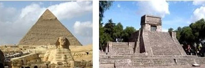
Ancient Civilizations including How the Egyptian Pyramids were built.
YouTube Video: Museum of Cycladic Art in Athens, which tells a day life in Ancient Greece
Pictured: LEFT: Ancient Egypt is a canonical example of an early culture considered a civilization; RIGHT: The Aztec Pyramid at St. Cecilia Acatitlan, State of Mexico
A civilization is any complex society characterized by urban development, social stratification, symbolic communication forms (typically, writing systems), and a perceived separation from and domination over the natural environment by a cultural elite.
Civilizations are intimately associated with and often further defined by other socio-politico-economic characteristics, including centralization, the domestication of both humans and other organisms, labor specialization, culturally ingrained ideologies of progress and supremacism, monumental architecture, taxation, societal dependence upon farming as an agricultural practice, and growth.
Historically, a civilization was a so-called "advanced" culture in contrast to more supposedly primitive cultures. In this broad sense, a civilization contrasts with non-centralized tribal societies, including the cultures of nomadic pastoralists, egalitarian horticultural subsistence neolithic societies or hunter-gatherers.
Civilizations are organized in densely populated settlements divided into hierarchical social classes with a ruling elite and subordinate urban and rural populations, which engage in intensive agriculture, mining, small-scale manufacture and trade. Civilization concentrates power, extending human control over the rest of nature, including over other human beings.
The earliest emergence of civilizations is generally associated with the final stages of the Neolithic Revolution, culminating in the relatively rapid process of urban revolution and formation of state, a political development associated with the appearance of a governing elite.
The earlier neolithic technology and lifestyle was established first in the Middle East (for example at Göbekli Tepe, from about 9,130 BCE), and later in the Yangtze and Yellow River basins in China (for example the Pengtoushan culture from 7,500 BCE), and later spread. Similar pre-civilized "neolithic revolutions" also began independently from 7,000 BCE in such places as northwestern South America (the Norte Chico civilization) and Mesoamerica.
These were among the six civilizations worldwide that arose independently. Mesopotamia is the site of the earliest developments of the Neolithic Revolution from around 10,000 BCE, with civilizations developing from 6,500 years ago. This area has been identified as having inspired some of the most important developments in human history including the invention of the wheel, the development of cursive script, mathematics, astronomy and agriculture.
The civilized urban revolution in turn was dependent upon the development of sedentarism, the domestication of grains and animals and development of lifestyles that facilitated economies of scale and accumulation of surplus production by certain social sectors.
The transition from complex cultures to civilizations, while still disputed, seems to be associated with the development of state structures, in which power was further monopolized by an elite ruling class who practiced human sacrifice.
Towards the end of the Neolithic period, various elitist Chalcolithic civilizations began to rise in various "cradles" from around 3300 BCE. Chalcolithic civilizations, as defined above, also developed in Pre-Columbian Americas and, despite an early start in Egypt, Axum and Kush, much later in Iron Age sub-Saharan Africa.
The Bronze Age collapse was followed by the Iron Age around 1200 BCE, during which a number of new civilizations emerged, culminating in a period from the 8th to the 3rd century BCE which German psychiatrist and philosopher Karl Jaspers termed the Axial Age, and which he claimed was a critical transitional phase leading to Classical civilization.
A major technological and cultural transition to modernity began approximately 1500 CE in Western Europe, and from this beginning new approaches to science and law spread rapidly around the world, incorporating earlier cultures into the industrial and technological civilization of the present.
Click on any of the following blue hyperlinks for more about Ancient Civilizations:
How the Egyptian Pyramids Were Built.
There have been many hypotheses about the Egyptian pyramid construction techniques. These techniques seem to have developed over time; later pyramids were not built the same way as earlier ones. Most of the construction hypotheses are based on the idea that huge stones were carved with copper chisels from stone quarries, and these blocks were then dragged and lifted into position. Disagreements chiefly concern the methods used to move and place the stones.
In addition to the many unresolved arguments about the construction techniques, there have been disagreements as to the kind of workforce used. The Greeks, many years after the event, believed that the pyramids must have been built by slave labor.
Archaeologists now believe that the Great Pyramid of Giza (at least) was built by tens of thousands of skilled workers who camped near the pyramids and worked for a salary or as a form of tax payment (levy) until the construction was completed, pointing to workers' cemeteries discovered in 1990 by archaeologists Zahi Hawass and Mark Lehner. For the Middle Kingdom Pyramid of Amenemhat II, there is evidence from the annal stone of the king that foreigners from Palestine were used.
Click on any of the following blue hyperlinks for more about how the Egyptian Great Pyramids were built:
Civilizations are intimately associated with and often further defined by other socio-politico-economic characteristics, including centralization, the domestication of both humans and other organisms, labor specialization, culturally ingrained ideologies of progress and supremacism, monumental architecture, taxation, societal dependence upon farming as an agricultural practice, and growth.
Historically, a civilization was a so-called "advanced" culture in contrast to more supposedly primitive cultures. In this broad sense, a civilization contrasts with non-centralized tribal societies, including the cultures of nomadic pastoralists, egalitarian horticultural subsistence neolithic societies or hunter-gatherers.
Civilizations are organized in densely populated settlements divided into hierarchical social classes with a ruling elite and subordinate urban and rural populations, which engage in intensive agriculture, mining, small-scale manufacture and trade. Civilization concentrates power, extending human control over the rest of nature, including over other human beings.
The earliest emergence of civilizations is generally associated with the final stages of the Neolithic Revolution, culminating in the relatively rapid process of urban revolution and formation of state, a political development associated with the appearance of a governing elite.
The earlier neolithic technology and lifestyle was established first in the Middle East (for example at Göbekli Tepe, from about 9,130 BCE), and later in the Yangtze and Yellow River basins in China (for example the Pengtoushan culture from 7,500 BCE), and later spread. Similar pre-civilized "neolithic revolutions" also began independently from 7,000 BCE in such places as northwestern South America (the Norte Chico civilization) and Mesoamerica.
These were among the six civilizations worldwide that arose independently. Mesopotamia is the site of the earliest developments of the Neolithic Revolution from around 10,000 BCE, with civilizations developing from 6,500 years ago. This area has been identified as having inspired some of the most important developments in human history including the invention of the wheel, the development of cursive script, mathematics, astronomy and agriculture.
The civilized urban revolution in turn was dependent upon the development of sedentarism, the domestication of grains and animals and development of lifestyles that facilitated economies of scale and accumulation of surplus production by certain social sectors.
The transition from complex cultures to civilizations, while still disputed, seems to be associated with the development of state structures, in which power was further monopolized by an elite ruling class who practiced human sacrifice.
Towards the end of the Neolithic period, various elitist Chalcolithic civilizations began to rise in various "cradles" from around 3300 BCE. Chalcolithic civilizations, as defined above, also developed in Pre-Columbian Americas and, despite an early start in Egypt, Axum and Kush, much later in Iron Age sub-Saharan Africa.
The Bronze Age collapse was followed by the Iron Age around 1200 BCE, during which a number of new civilizations emerged, culminating in a period from the 8th to the 3rd century BCE which German psychiatrist and philosopher Karl Jaspers termed the Axial Age, and which he claimed was a critical transitional phase leading to Classical civilization.
A major technological and cultural transition to modernity began approximately 1500 CE in Western Europe, and from this beginning new approaches to science and law spread rapidly around the world, incorporating earlier cultures into the industrial and technological civilization of the present.
Click on any of the following blue hyperlinks for more about Ancient Civilizations:
- History of the concept
- Characteristics
- Cultural identity
- Complex systems
- History
- Fall of civilizations
- Future
- See also:
- Anarcho-primitivism
- Barbarian
- Civilized core
- Cradle of civilization
- Culture
- Outline of culture
- Historical powers
- History of the world
- Human population
- Intermediate Region
- Kardashev scale
- Law of Life
- Mission civilisatrice
- Muslim world
- New Tribalism
- Proto-civilization
- Sedentism
- Western civilization
- Christendom
- Role of the Christian Church in civilization
- Future Shock
- The dictionary definition of civilization at Wiktionary
- Quotations related to Civilization at Wikiquote
- BBC on civilization
- Top 10 oldest civilizations
How the Egyptian Pyramids Were Built.
There have been many hypotheses about the Egyptian pyramid construction techniques. These techniques seem to have developed over time; later pyramids were not built the same way as earlier ones. Most of the construction hypotheses are based on the idea that huge stones were carved with copper chisels from stone quarries, and these blocks were then dragged and lifted into position. Disagreements chiefly concern the methods used to move and place the stones.
In addition to the many unresolved arguments about the construction techniques, there have been disagreements as to the kind of workforce used. The Greeks, many years after the event, believed that the pyramids must have been built by slave labor.
Archaeologists now believe that the Great Pyramid of Giza (at least) was built by tens of thousands of skilled workers who camped near the pyramids and worked for a salary or as a form of tax payment (levy) until the construction was completed, pointing to workers' cemeteries discovered in 1990 by archaeologists Zahi Hawass and Mark Lehner. For the Middle Kingdom Pyramid of Amenemhat II, there is evidence from the annal stone of the king that foreigners from Palestine were used.
Click on any of the following blue hyperlinks for more about how the Egyptian Great Pyramids were built:
- Historical hypotheses
- Third through Fifth Dynasties
Middle Kingdom and onward
- Third through Fifth Dynasties
- Great Pyramid
- See also:
- List of megalithic sites
- Theories about Stonehenge
- Seven wonders of the world
- The Herodotus Machine
- How to Build a Pyramid, Archaeology Magazine, May/June 2007
- Engineering the Pyramids - Materials Science and Engineering @ Drexel University
- Rope pull hypothesis - alternative hypothesis by Heribert Illig and Franz Löhner
- Did the Great Pyramid Have an Elevator? The Structural Engineer, April 2009
- The main problems / drawbacks of all ramp systems
- 3D Unveils Great Pyramid's Mystery - illustrates hypothesis of Houdin and Brier.
Human Migration
YouTube Video Animated map shows how humans migrated across the globe
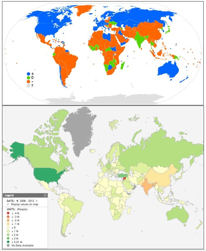
PICTURED BELOW:
TOP: Net migration rates for 2016: positive (blue), negative (orange), stable (green), and no data (gray) (Courtesy of Kamalthebest - Own work, derived from File:BlankMap-World-Microstates.svg, using this CIA Factbook source, CC BY-SA 4.0
BOTTOM: Net migration by Nation (2008 -2012)
Worldwide Human migration is the movement by people from one place to another with the intentions of settling, permanently in the new location. The movement is often over long distances and from one country to another, but internal migration is also possible; indeed, this is the dominant form globally. Migration may be individuals, family units or in large groups.
Nomadic movements are normally not regarded as migrations as there is no intention to settle in the new place and because the movement is generally seasonal. Only a few nomadic people have retained this form of lifestyle in modern times. Also, the temporary movement of people for the purpose of travel, tourism, pilgrimages, or the commute is not regarded as migration, in the absence of an intention to live and settle in the visited places.
Many estimates of statistics in worldwide migration patterns exist.
The World Bank has published its Migration and Remittances Factbook annually since 2008. The International Organisation for Migration (IOM) has published a yearly World Migration Report since 1999. The United Nations Statistics Division also keeps a database on worldwide migration.
Recent advances in research on migration via the Internet promise better understanding of migration patterns and migration motives.
Substantial internal migration can also take place within a country, either seasonal human migration (mainly related to agriculture and to tourism to urban places), or shifts of population into cities (urbanisation) or out of cities (suburbanisation). Studies of worldwide migration patterns, however, tend to limit their scope to international migration.
The World Bank's Migration and Remittances Factbook of 2011 lists the following estimates for the year 2010: total number of immigrants: 215.8 million or 3.2% of world population. In 2013, the percentage of international migrants worldwide increased by 33% with 59% of migrants targeting developed regions.
Almost half of these migrants are women, which is one of the most significant migrant-pattern changes in the last half century. Women migrate alone or with their family members and community. Even though female migration is largely viewed as associations rather than independent migration, emerging studies argue complex and manifold reasons for this.
A distinction can be made between voluntary and involuntary migration, or between refugees fleeing political conflict or natural disaster vs. economic or labor migration, but these distinctions are difficult to make and partially subjective, as the motivators for migration are often correlated.
The World Bank's report estimates that, as of 2010, 16.3 million or 7.6% of migrants qualified as refugees. At the end of 2012, approximately 15.4 million people were refugees and persons in refugee-like situations - 87% of them found asylum in developing countries.
Structurally, there is substantial South-South and North-North migration, i.e., most emigrants from high-income O.E.C.D. countries migrate to other high-income countries, and a substantial part (estimated at 43%) of emigrants from developing countries migrate to other developing countries.
The United Nations Population Fund says that "[while the North has experienced a higher absolute increase in the migrant stock since 2000 (32 million) compared to the South (25 million), the South recorded a higher growth rate. Between 2000 and 2013 the average annual rate of change of the migrant population in the developing regions (2.3%) slightly exceeded that of the developed regions (2.1%).
The top ten immigration countries are:
The top ten countries of origin are:
The top ten migration corridors worldwide are:
1. Libya–European Union
2. Mexico–United States;
3. Russia–Ukraine;
4. Ukraine–Russia;
5. Bangladesh–India;
6. Turkey–Germany;
7. Kazakhstan–Russia;
8. Russia–Kazakhstan;
9. China mainland–Hong Kong;
10. China–United States.
Remittances, i.e., funds transferred by migrant workers to their home country, form a substantial part of the economy of some countries. The top ten remittance recipients in 2010 were (estimates in billion US dollar):
The Global Commission on International Migration (GCIM), launched in 2003, published a report in 2005. International migration challenges at the global level are addressed through the Global Forum on Migration and Development and the Global Migration Group, both established in 2006.
The United Nations reported that 2014 had the highest level of forced migration on record: 59.5 million individuals, caused by "persecution, conflict, generalized violence, or human rights violations", as compared with 51.2 million in 2013 (an increase of 8.3 million) and with 37.5 million a decade prior.
As of 2015 one of every 122 humans is a refugee, internally displaced, or seeking asylum. National Geographic has published 5 maps showing human migrations in progress in 2015 based on the UN report.
Click on any of the following blue hyperlinks for more about Worldwide Human Migration:
Nomadic movements are normally not regarded as migrations as there is no intention to settle in the new place and because the movement is generally seasonal. Only a few nomadic people have retained this form of lifestyle in modern times. Also, the temporary movement of people for the purpose of travel, tourism, pilgrimages, or the commute is not regarded as migration, in the absence of an intention to live and settle in the visited places.
Many estimates of statistics in worldwide migration patterns exist.
The World Bank has published its Migration and Remittances Factbook annually since 2008. The International Organisation for Migration (IOM) has published a yearly World Migration Report since 1999. The United Nations Statistics Division also keeps a database on worldwide migration.
Recent advances in research on migration via the Internet promise better understanding of migration patterns and migration motives.
Substantial internal migration can also take place within a country, either seasonal human migration (mainly related to agriculture and to tourism to urban places), or shifts of population into cities (urbanisation) or out of cities (suburbanisation). Studies of worldwide migration patterns, however, tend to limit their scope to international migration.
The World Bank's Migration and Remittances Factbook of 2011 lists the following estimates for the year 2010: total number of immigrants: 215.8 million or 3.2% of world population. In 2013, the percentage of international migrants worldwide increased by 33% with 59% of migrants targeting developed regions.
Almost half of these migrants are women, which is one of the most significant migrant-pattern changes in the last half century. Women migrate alone or with their family members and community. Even though female migration is largely viewed as associations rather than independent migration, emerging studies argue complex and manifold reasons for this.
A distinction can be made between voluntary and involuntary migration, or between refugees fleeing political conflict or natural disaster vs. economic or labor migration, but these distinctions are difficult to make and partially subjective, as the motivators for migration are often correlated.
The World Bank's report estimates that, as of 2010, 16.3 million or 7.6% of migrants qualified as refugees. At the end of 2012, approximately 15.4 million people were refugees and persons in refugee-like situations - 87% of them found asylum in developing countries.
Structurally, there is substantial South-South and North-North migration, i.e., most emigrants from high-income O.E.C.D. countries migrate to other high-income countries, and a substantial part (estimated at 43%) of emigrants from developing countries migrate to other developing countries.
The United Nations Population Fund says that "[while the North has experienced a higher absolute increase in the migrant stock since 2000 (32 million) compared to the South (25 million), the South recorded a higher growth rate. Between 2000 and 2013 the average annual rate of change of the migrant population in the developing regions (2.3%) slightly exceeded that of the developed regions (2.1%).
The top ten immigration countries are:
- the United States
- the Russian Federation
- Germany
- Saudi Arabia
- Canada
- the UK
- France
- Australia
- India
The top ten countries of origin are:
- Mexico
- Spain
- the Russian Federation
- China
- Ukraine
- Bangladesh
- Pakistan
- the UK
- the Philippines
- Turkey
The top ten migration corridors worldwide are:
1. Libya–European Union
2. Mexico–United States;
3. Russia–Ukraine;
4. Ukraine–Russia;
5. Bangladesh–India;
6. Turkey–Germany;
7. Kazakhstan–Russia;
8. Russia–Kazakhstan;
9. China mainland–Hong Kong;
10. China–United States.
Remittances, i.e., funds transferred by migrant workers to their home country, form a substantial part of the economy of some countries. The top ten remittance recipients in 2010 were (estimates in billion US dollar):
- India (55; 2.7% of GDP),
- China (51; 0.5% of GNP),
- Mexico (22.6; 1.8% of GDP),
- Philippines (21.3; 7.8% of GDP),
- France (15.9; 0.5% of GDP),
- Germany (11.6; 0.2% of GDP),
- Bangladesh (11.1; 7.2% of GDP),
- Belgium (10.4; 1.9% of GDP),
- Spain (10.2; 0.7% of GDP),
- Nigeria (10.0; 1.9% of GDP).
The Global Commission on International Migration (GCIM), launched in 2003, published a report in 2005. International migration challenges at the global level are addressed through the Global Forum on Migration and Development and the Global Migration Group, both established in 2006.
The United Nations reported that 2014 had the highest level of forced migration on record: 59.5 million individuals, caused by "persecution, conflict, generalized violence, or human rights violations", as compared with 51.2 million in 2013 (an increase of 8.3 million) and with 37.5 million a decade prior.
As of 2015 one of every 122 humans is a refugee, internally displaced, or seeking asylum. National Geographic has published 5 maps showing human migrations in progress in 2015 based on the UN report.
Click on any of the following blue hyperlinks for more about Worldwide Human Migration:
- Theories for migration for work in the 21st century
- Historical theories
- See also
- Colonization
- Diaspora
- Early human migrations
- Environmental migrant
- Existential migration
- Feminization of migration
- Globalisation
- Humanitarian crisis
- Illegal immigration
- Religion and human migration
- Job migration
- Linguistic Diversity in Space and Time
- List of diasporas
- Expatriate
- Migrant literature
- Immigration to Europe
- Migration in the People's Republic of China
- Most recent common ancestor
- People flow
- Political demography
- iom.int, The International Organisation for Migration
- CIA World Factbook gives up-to-date statistics on net immigration by country.
- Western Sahara and Migration
- Stalker's Guide to International Migration Comprehensive interactive guide to modern migration issues, with maps and statistics
- Mass migration as a travel business
- Migration, refugees and displacement (UNDP) provides background and statistics on human migration.
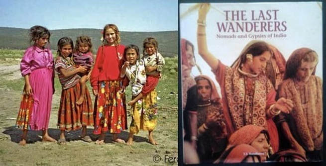
Nomads including a List of Nomadic People
YouTube Video: Who Are The Bedouin Nomads Of The Middle East?
Pictured: (L) Europe: Hungarian gypsy nomads; (R) Nomads and Gypsies of India
Click here for a List of Nomadic People by Country.
A nomad is a member of a community of people who live in different locations, moving from one place to another. Among the various ways nomads relate to their environment, one can distinguish the hunter-gatherer, the pastoral nomad owning livestock, or the "modern" peripatetic nomad. As of 1995, there were an estimated 30–40 million nomads in the world.
Nomadic hunting and gathering, following seasonally available wild plants and game, is by far the oldest human subsistence method. Pastoralists raise herds, driving them, or moving with them, in patterns that normally avoid depleting pastures beyond their ability to recover.
Nomadism is also a lifestyle adapted to infertile regions such as steppe, tundra, or ice and sand, where mobility is the most efficient strategy for exploiting scarce resources. For example, many groups in the tundra are reindeer herders and are semi-nomadic, following forage for their animals.
These nomads sometimes adapt the use of high technology such as solar photovoltaics to reduce their dependence on diesel fuel.
Sometimes also described as "nomadic" are the various itinerant populations who move about in densely populated areas living not on natural resources, but by offering services (craft or trade) to the resident population. These groups are known as "peripatetic nomads".
Common Characteristics:
A nomad is a person with no settled home, moving from place to place as a way of obtaining food, finding pasture for livestock, or otherwise making a living. The word Nomad comes from a Greek word that means one who wanders for pasture. Most nomadic groups follow a fixed annual or seasonal pattern of movements and settlements. Nomadic peoples traditionally travel by animal or canoe or on foot. Today, some nomads travel by motor vehicle. Most nomads live in tents or other portable shelters.
Nomads keep moving for different reasons. Nomadic foragers move in search of game, edible plants, and water. The Australian Aborigines, Negritos of Southeast Asia, and San of Africa, for example, traditionally move from camp to camp to hunt and to gather wild plants.
Some tribes of the Americas followed this way of life. Pastoral nomads make their living raising livestock, such as camels, cattle, goats, horses, sheep, or yaks. Gaddi tribe of Himachal Pradesh India is one such tribe. These nomads travel to find more camels, goats, and sheep through the deserts of Arabia and northern Africa.
The Fulani and their cattle travel through the grasslands of Niger in western Africa. Some nomadic peoples, especially herders, may also move to raid settled communities or avoid enemies. Nomadic craftworkers and merchants travel to find and serve customers. They include the Lohar blacksmiths of India, the Romani traders, and the Irish Travellers.
Most nomads travel in groups of families called bands or tribes. These groups are based on kinship and marriage ties or on formal agreements of cooperation. A council of adult males makes most of the decisions, though some tribes have chiefs.
In the case of Mongolian nomads, a family moves twice a year. These two movements would generally occur during the summer and winter. The winter location is usually located near mountains in a valley and most families already have their fixed winter locations. The winter locations have shelter for the animals and are not used by other families while they are out. In the summer they move to a more open area that the animals can graze.
Most nomads usually move in the same region and don't travel very far to a totally different region. Because they usually circle around a large area, a community gets formed and the other families generally know where the other ones are. Most often, a family would not have the resources to move from one province to another unless they are moving out of the area permanently.
A family can move on its own or with others and if it moves alone, they are usually no more than a couple of kilometers from each other. In the modern day there are no tribes and the people make decisions among their family members, although they consult with the elders on usual matters.
The geographical closeness of families are usually for mutual support. Pastoral nomad societies usually do not have large population. One such society, the Mongols, gave rise to the largest land empire in history. The Mongols originally consisted of loosely organized nomadic tribes in Mongolia, Manchuria, and Siberia. In the late 12th century, Genghis Khan united them and other nomadic tribes to found the Mongol Empire, which eventually stretched the length of Asia.
The nomadic way of life has become increasingly rare. Many governments dislike nomads because it is difficult to control their movement and to obtain taxes from them. Many countries have converted pastures into cropland and forced nomadic peoples into permanent settlements.
Click on any of the following blue hyperlinks for more about the Nomadic lifestyle:
- Hunter-gatherers
- Pastoralism
- Origin
- Increase in post-Soviet Central Asia
Sedentarization
- Contemporary peripatetic minorities in Europe and Asia
- Romani people
Dom people
Yörüks
- Romani people
- Image gallery
- See also:
Economic Ranking of Countries by: Gross Domestic Product (GDP) vs. by Purchasing Power Parity (PPP)
YouTube Video: Top 10 Richest Countries by GDP (PPP) per capita
Pictured: Economic Ranking of Countries (L) by GDP and (R) by PPP
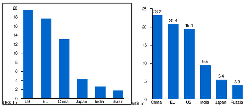
Click here for a List of Countries by Gross Domestic Product (GDP):
Gross domestic product (GDP) is the market value of all final goods and services from a nation in a given year. Countries are sorted by nominal GDP estimates from financial and statistical institutions, which are calculated at market or government official exchange rates.
Nominal GDP does not take into account differences in the cost of living in different countries, and the results can vary greatly from one year to another based on fluctuations in the exchange rates of the country's currency. Such fluctuations may change a country's ranking from one year to the next, even though they often make little or no difference in the standard of living of its population.
Comparisons of national wealth are also frequently made on the basis of purchasing power parity (PPP), to adjust for differences in the cost of living in different countries. PPP largely removes the exchange rate problem, but has its own drawbacks; it does not reflect the value of economic output in international trade, and it also requires more estimation than nominal GDP. On the whole, PPP per capita figures are less spread than nominal GDP per capita figures.
The United States is the world's largest economy with a GDP of approximately $18.56 trillion, notably due to high average incomes, a large population, capital investment, moderate unemployment, high consumer spending, a relatively young population, and technological innovation.
Tuvalu is the world's smallest national economy with a GDP of about $32 million because of its very small population, a lack of natural resources, reliance on foreign aid, negligible capital investment, demographic problems, and low average incomes.
Although the rankings of national economies have changed considerably over time, the United States has maintained its top position since the Gilded Age, a time period in which its economy saw rapid expansion, surpassing the British Empire and Qing dynasty in aggregate output.
Since China's transition to a market-based economy through privatization and deregulation, the country has seen its ranking increase from ninth in 1978 to second to only the United States in 2016 as economic growth accelerated and its share of global nominal GDP surged from 2% in 1980 to 15% in 2016.
India has also experienced a similar economic boom since the implementation of neoliberal reforms in the early 1990s.
When supranational entities are included, the European Union is the second largest economy in the world. It was the largest from 2004, when ten countries joined the union, to 2014, after which it was surpassed by the United States.
The first list largely includes data compiled by the International Monetary Fund's World Economic Outlook for 2016, the second list shows the World Bank's 2016 estimates, and the third list includes data compiled by the United Nations Statistics Division for 2015.
Several economies which are not considered to be countries (the world, the European Union, and some dependent territories) are included in the lists because they appear in the sources as distinct economies. These economies are italicized and not ranked in the charts, but are listed where applicable.
___________________________________________________________________________
Click here for a List of Countries by their estimated forecast of gross domestic product based on purchasing power parity, abbreviated GDP (PPP):
Countries are sorted by GDP PPP forecast estimates from financial and statistical institutions in the limited period January-April 2017, which are calculated at market or government official exchange rates. The data given on this page are based on the international dollar, a standardized unit used by economists.
GDP comparisons using PPP are arguably more useful than those using nominal GDP when assessing a nation's domestic market because PPP takes into account the relative cost of local goods, services and inflation rates of the country, rather than using international market exchange rates which may distort the real differences in per capita income.
It is however limited when measuring financial flows between countries. PPP is often used to gauge global poverty thresholds and is used by the United Nations in constructing the human development index. These surveys such as the International Comparison Program include both tradable and non-tradable goods in an attempt to estimate a representative basket of all goods.
The first table includes estimates for the year 2017 for all current 191 International Monetary Fund (IMF) members as well as Hong Kong and Taiwan (the official list says "Taiwan, Province of China").
Data are in millions of international dollars; they were calculated by the IMF. Figures were published in April 2017.
The second table includes data, mostly for the year 2015, for 180 of the 193 current United Nations member states as well as Hong Kong and Macau (the two Chinese Special Administrative Regions). Data are in billions of international dollars; they were compiled by the World Bank.
The third table is a tabulation of the CIA World Factbook Gross Domestic Product (GDP) (Purchasing Power Parity) data update of 2016. The data for GDP at purchasing power parity have also been rebased using the new International Comparison Program price surveys and extrapolated to 2007.
Click on any of the following blue hyperlinks for more about The List of Countries by GDP/PPP:
- List of countries by GDP (nominal) per capita
- List of countries by GDP (PPP) per capita
- List of IMF ranked countries by GDP, IMF ranked GDP (nominal), GDP (nominal) per capita, GDP (PPP), GDP (PPP) per capita, Population, and PPP
- List of IMF ranked countries by past and projected GDP (PPP)
- List of countries by real GDP growth rate
- List of countries by Human Development Index
- List of countries by income equality
- List of countries by distribution of wealth
- Lists of countries by GDP
- National wealth
Countries including a List of Countries and any of their Territories
YouTube Video: Countries of the World/Countries of the World Song
Pictured: Map showing the countries of the world.
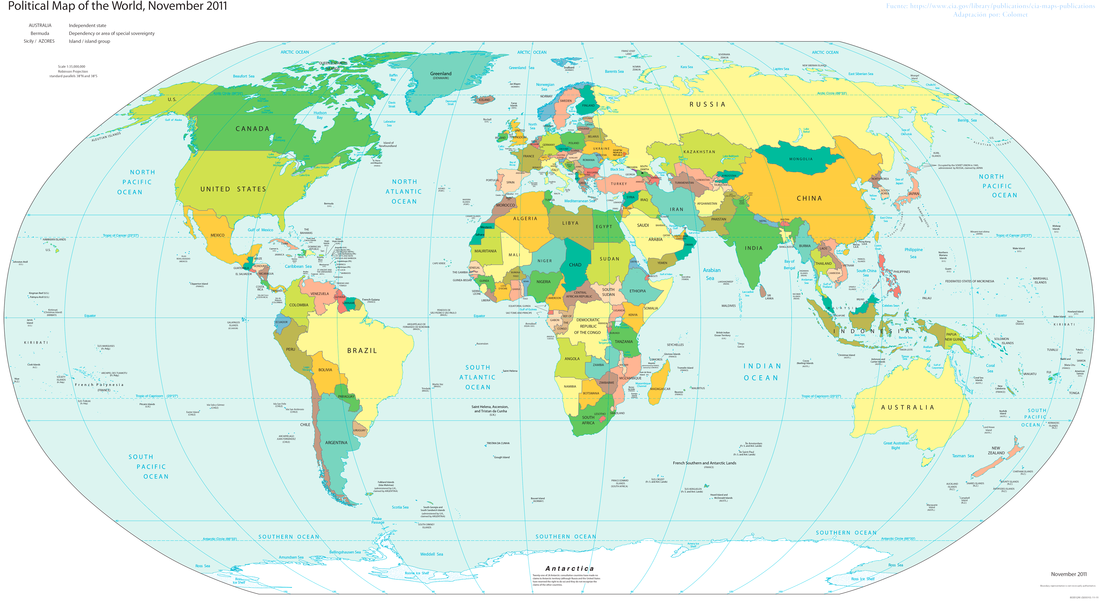
Click here for a List of Countries and any Territories.
A country is a region that is identified as a distinct national entity in political geography. A country may be an independent sovereign state or one that is occupied by another state, as a non-sovereign or formerly sovereign political division, or a geographic region associated with sets of previously independent or differently associated people with distinct political characteristics.
Regardless of the physical geography, in the modern internationally accepted legal definition as defined by the League of Nations in 1937 and reaffirmed by the United Nations in 1945, a resident of a country is subject to the independent exercise of legal jurisdiction.
Sometimes countries refers both to sovereign states and to other political entities, while other times it refers only to states. For example, the CIA World Factbook uses the word in its "Country name" field to refer to "a wide variety of dependencies, areas of special sovereignty, uninhabited islands, and other entities in addition to the traditional countries or independent states".
In English the word "Country" has increasingly become associated with political divisions, so that one sense, associated with the indefinite article – "a country" – through misuse and subsequent conflation is now a synonym for state, or a former sovereign state, in the sense of sovereign territory or "district, native land". Areas much smaller than a political state may be called by names such as the West Country in England, the Black Country (a heavily industrialized part of England), "Constable Country" (a part of East Anglia painted by John Constable), the "big country" (used in various contexts of the American West), "coal country" (used of parts of the US and elsewhere) and many other terms.
The equivalent terms in French and other Romance languages (pays and variants) have not carried the process of being identified with political sovereign states as far as the English "country", instead derived from, pagus, which designated the territory controlled by a medieval count, a title originally granted by the Roman Church.
In many European countries the words are used for sub-divisions of the national territory, as in the German Bundesländer, as well as a less formal term for a sovereign state. France has very many "pays" that are officially recognized at some level, and are either natural regions, like the Pays de Bray, or reflect old political or economic entities, like the Pays de la Loire.
A version of "country" can be found in the modern French language as contrée, based on the word cuntrée in Old French, that is used similarly to the word "pays" to define non-state regions, but can also be used to describe a political state in some particular cases. The modern Italian contrada is a word with its meaning varying locally, but usually meaning a ward or similar small division of a town, or a village or hamlet in the countryside.
Click on any of the following blue hyperlinks for more about Countries:
- Sovereignty status
- See also:
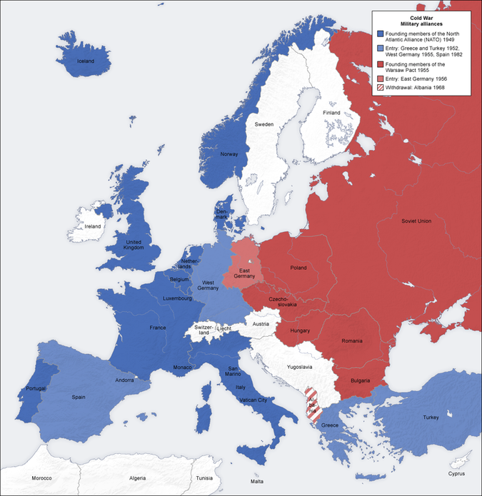
Military Alliances around the Globe, including a List
YouTube Video about the Cold War: Berlin
Pictured: a Map of the Two military alliances (NATO and Warsaw Pact) in Europe during the Cold War (Courtesy of SA 3.0)
Click here for a List of Military Alliances Since Biblical Times
A military alliance is an international agreement concerning national security, when the contracting parties promise to support each other in case of a crisis that has not been identified in advance.
Military alliances differ from coalitions, as coalitions are formed for a crisis that are already known.
Military alliances can be classified as defense pacts, non-aggression pacts and ententes.
Characteristics:
Military alliances are related to collective security systems but can differ in nature. An early 1950s memorandum from the United States Department of State explained the difference by saying, that historically alliances "were designed to advance the respective nationalistic interests of the parties, and provided for joint military action if one of the parties in pursuit of such objectives became involved in war".
While a collective security arrangement "is directed against no one; it is directed solely against aggression. It seeks not to influence any shifting 'balance of power' but to strengthen the 'balance of principle'".
The obvious motivation in states engaging in military alliances is to protect themselves against threats from other countries.
However states have also entered into alliances to improves ties with a particular nation or to manage conflict with a particular nation.
The nature of alliances, including their formation and cohesiveness (or lack thereof), is a subject of much academic study past and present, with the leading scholars generally considered to be Glenn H. Snyder and Stephen Walt.
Click here for European historiography
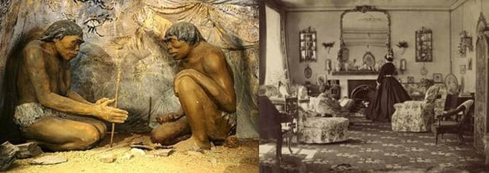
History of Human Habitats and Population
YouTube Video: Early human habitat, recreated for first time, shows life was no picnic
Pictured: (L) Early Humans making fire inside their cave; (R) 1800'S Victorian House
Habitat and Population:
Further information: Human migration, Demography, and World population
Early human settlements were dependent on proximity to water and, depending on the lifestyle, other natural resources used for subsistence, such as populations of animal prey for hunting and arable land for growing crops and grazing livestock.
But humans have a great capacity for altering their habitats by means of technology, through the following means:
But human settlements continue to be vulnerable to natural disasters, especially those placed in hazardous locations and characterized by lack of quality of construction.
Deliberate habitat alteration is often done with the goals of increasing material wealth, increasing thermal comfort, improving the amount of food available, improving aesthetics, or improving ease of access to resources or other human settlements.
With the advent of large-scale trade and transport infrastructure, proximity to these resources has become unnecessary, and in many places, these factors are no longer a driving force behind the growth and decline of a population.
Nonetheless, the manner in which a habitat is altered is often a major determinant in population change. Technology has allowed humans to colonize six of the Earth's seven continents and adapt to virtually all climates. However the human population is not uniformly distributed on the Earth's surface, because the population density varies from one region to another and there are large areas almost completely uninhabited, like Antarctica.
Within the last century, humans have explored Antarctica, underwater environment, and outer space, although large-scale colonization of these environments is not yet feasible.
With a population of over seven billion, humans are among the most numerous of the large mammals. Most humans (61%) live in Asia. The remainder live in the Americas (14%), Africa (14%), Europe (11%), and Oceania (0.5%).
Human habitation within closed ecological systems in hostile environments, such as Antarctica and outer space, is expensive, typically limited in duration, and restricted to scientific, military, or industrial expeditions.
Life in space has been very sporadic, with no more than thirteen humans in space at any given time. Between 1969 and 1972, two humans at a time spent brief intervals on the Moon. As of September 2017, no other celestial body has been visited by humans, although there has been a continuous human presence in space since the launch of the initial crew to inhabit the International Space Station on October 31, 2000. However, other celestial bodies have been visited by human-made objects.
Since 1800, the human population has increased from one billion to over seven billion, In 2004, some 2.5 billion out of 6.3 billion people (39.7%) lived in urban areas. In February 2008, the U.N. estimated that half the world's population would live in urban areas by the end of the year. Problems for humans living in cities include various forms of pollution and crime, especially in inner city and suburban slums. Both overall population numbers and the proportion residing in cities are expected to increase significantly in the coming decades.
Humans have had a dramatic effect on the environment. Humans are apex predators, being rarely preyed upon by other species. Currently, through land development, combustion of fossil fuels, and pollution, humans are thought to be the main contributor to global climate change. If this continues at its current rate it is predicted that climate change will wipe out half of all plant and animal species over the next century.
See Also:
Further information: Human migration, Demography, and World population
Early human settlements were dependent on proximity to water and, depending on the lifestyle, other natural resources used for subsistence, such as populations of animal prey for hunting and arable land for growing crops and grazing livestock.
But humans have a great capacity for altering their habitats by means of technology, through the following means:
- irrigation,
- urban planning,
- construction,
- transport,
- manufacturing goods,
- deforestation,
- and desertification.
But human settlements continue to be vulnerable to natural disasters, especially those placed in hazardous locations and characterized by lack of quality of construction.
Deliberate habitat alteration is often done with the goals of increasing material wealth, increasing thermal comfort, improving the amount of food available, improving aesthetics, or improving ease of access to resources or other human settlements.
With the advent of large-scale trade and transport infrastructure, proximity to these resources has become unnecessary, and in many places, these factors are no longer a driving force behind the growth and decline of a population.
Nonetheless, the manner in which a habitat is altered is often a major determinant in population change. Technology has allowed humans to colonize six of the Earth's seven continents and adapt to virtually all climates. However the human population is not uniformly distributed on the Earth's surface, because the population density varies from one region to another and there are large areas almost completely uninhabited, like Antarctica.
Within the last century, humans have explored Antarctica, underwater environment, and outer space, although large-scale colonization of these environments is not yet feasible.
With a population of over seven billion, humans are among the most numerous of the large mammals. Most humans (61%) live in Asia. The remainder live in the Americas (14%), Africa (14%), Europe (11%), and Oceania (0.5%).
Human habitation within closed ecological systems in hostile environments, such as Antarctica and outer space, is expensive, typically limited in duration, and restricted to scientific, military, or industrial expeditions.
Life in space has been very sporadic, with no more than thirteen humans in space at any given time. Between 1969 and 1972, two humans at a time spent brief intervals on the Moon. As of September 2017, no other celestial body has been visited by humans, although there has been a continuous human presence in space since the launch of the initial crew to inhabit the International Space Station on October 31, 2000. However, other celestial bodies have been visited by human-made objects.
Since 1800, the human population has increased from one billion to over seven billion, In 2004, some 2.5 billion out of 6.3 billion people (39.7%) lived in urban areas. In February 2008, the U.N. estimated that half the world's population would live in urban areas by the end of the year. Problems for humans living in cities include various forms of pollution and crime, especially in inner city and suburban slums. Both overall population numbers and the proportion residing in cities are expected to increase significantly in the coming decades.
Humans have had a dramatic effect on the environment. Humans are apex predators, being rarely preyed upon by other species. Currently, through land development, combustion of fossil fuels, and pollution, humans are thought to be the main contributor to global climate change. If this continues at its current rate it is predicted that climate change will wipe out half of all plant and animal species over the next century.
See Also:
- City,
- Town,
- Nomad,
- Camping,
- Farm,
- House,
- Watercraft,
- Infrastructure,
- Architecture,
- Building,
- and Engineering
History of Mankind
YouTube Video: Mankind: the Story of All of Us
YouTube Video: Mankind: The Story of All of Us -- Birth of Farming | History
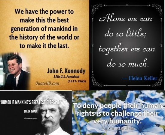
Pictured Below Inspiring Quotes by (Clockwise from Upper Left) John F. Kennedy, Helen Keller, Nelson Mandela, and Mark Twain
The history of the world is the history of humanity (or human history), as determined from archaeology, anthropology, genetics, linguistics, and other disciplines; and, for periods since the invention of writing, from recorded history and from secondary sources and studies.
Humanity's written history was preceded by its prehistory, beginning with the Palaeolithic Era ("Early Stone Age"), followed by the Neolithic Era ("New Stone Age"). The Neolithic saw the Agricultural Revolution begin, between 8000 and 5000 BCE, in the Near East's Fertile Crescent.
The Agricultural Revolution marked a fundamental change in history, with humans beginning the systematic husbandry of plants and animals. As agriculture advanced, most humans transitioned from a nomadic to a settled lifestyle as farmers in permanent settlements. The relative security and increased productivity provided by farming allowed communities to expand into increasingly larger units, fostered by advances in transportation.
Whether in prehistoric or historic times, people always had to be near reliable sources of potable water. Cities developed on river banks as early as 3000 BCE, when some of the first well-developed settlements arose in Mesopotamia, on the banks of Egypt's Nile River, in the Indus River valley, and along China's rivers.
As farming developed, grain agriculture became more sophisticated and prompted a division of labor to store food between growing seasons. Labor divisions led to the rise of a leisured upper class and the development of cities, which provided the foundation for civilization. The growing complexity of human societies necessitated systems of accounting and writing.
With civilizations flourishing, ancient history ("Antiquity," including the Classical Age, up to about 500 CE) saw the rise and fall of empires.
Post-classical history (the "Middle Ages," c. 500–1500 CE ) witnessed the rise of Christianity, the Islamic Golden Age (c. 750 CE – c. 1258 CE), and the early Italian Renaissance (from around 1300 CE).
The Early Modern Period, sometimes referred to as the "European Age", from about 1500 to 1800, included the Age of Enlightenment and the Age of Discovery. The mid-15th-century invention of modern printing, employing movable type, revolutionized communication and facilitated ever wider dissemination of information, helping end the Middle Ages and ushering in the Scientific Revolution.
By the 18th century, the accumulation of knowledge and technology had reached a critical mass that brought about the Industrial Revolution and began the Late Modern Period, which starts around 1800 and includes the current day.
This scheme of historical periodization (dividing history into Antiquity, Post-Classical, Early Modern, and Late Modern periods) was developed for, and applies best to, the history of the Old World, particularly Europe and the Mediterranean.
Outside this region, including ancient China and ancient India, historical timelines unfolded differently. However, by the 18th century, due to extensive world trade and colonization, the histories of most civilizations had become substantially intertwined.
In the last quarter-millennium, the rates of growth of population, knowledge, technology, communications, commerce, weapons destructiveness, and environmental degradation have greatly accelerated, creating opportunities and perils that now confront the planet's human communities.
Click on any of the following blue hyperlinks for more about History of Mankind:
- Prehistory
- Early humans
- Rise of civilization
- Ancient history
- Cradles of civilization
- Axial Age
- Regional empires
- Declines, falls and resurgence
- Post-classical history
- Middle East, Central Asia and North Africa
- Europe
- Sub-Saharan Africa
- South Asia
- East Asia
- Southeast Asia
- Oceania
- The Americas
- Modern history
- See also:
- Economic history of the world
- Historic recurrence
- Historiography
- List of archaeological periods
- List of millennia
- List of time periods
- Crash Course World History
- British Museum – A History of the World (archived).
- Pella, John & Erik Ringmar, History of International Relations Open Textbook Project, Cambridge: Open Book. (archived).
History of Clothing and Textiles over Time
YouTube Video: 100 Years of Clothing Fashion
YouTube Video: Cotton from Field to Fabric
Pictured: Different Clothing Styles from the Past to the Present

The history of clothing and textiles covers the availability and use of textiles and other materials and the development of technology for the making of clothing over human history.
The wearing of clothing is exclusively a human characteristic and is a feature of most human societies. It is not known when humans began wearing clothes but anthropologists believe that animal skins and vegetation were adapted into coverings as protection from cold, heat and rain, especially as humans migrated to new climates.
Clothing and textiles have been important in human history and reflect the materials available to a civilization as well as the technologies that had been mastered. The social significance of the finished product reflects their culture.
Textiles can be felt or spun fibers made into yarn and subsequently netted, looped, knit or woven to make fabrics, which appeared in the Middle East during the late stone age.
From the ancient times to the present day, methods of textile production have continually evolved, and the choices of textiles available have influenced how people carried their possessions, clothed themselves, and decorated their surroundings.
Sources available for the study of clothing and textiles include material remains discovered via archaeology; representation of textiles and their manufacture in art; and documents concerning the manufacture, acquisition, use, and trade of fabrics, tools, and finished garments. Scholarship of textile history, especially its earlier stages, is part of material culture studies.
Click on any of the following blue hyperlinks for more about the History of Clothing and Textiles:
- Prehistoric development
- Early adoption of apparel
- Ancient textiles and clothing
- Medieval clothing and textiles
- Renaissance and early modern period
- Mughal India
- Enlightenment and the Colonial period
- Industrial revolution
- Contemporary technology
- 21st century
- See also:
- History of fashion design
- History of hide materials
- History of silk
- History of Western fashion
- Otzi's clothing and shoes
- Timeline of clothing and textiles technology
- Spindle, Loom, and Needle – History of the Textile Industry
- Australian Museum of Clothing And Textiles Inc. at the Wayback Machine (archived 27 October 2009) – Why have a Museum of Clothing and Textiles?
- The drafting history of the Agreement on Textiles and Clothing
- American Women's History: A Research Guide Clothing and Fashion
- Historical Clothing/Fabric
- All Sewn Up: Millinery, Dressmaking, Clothing and Costume
- Gallery of English Medieval Clothing from 1906 by Dion Clayton Calthrop
Comparison of American vs. British EnglishPictured below: Examples of British vs. American English Usage for Transportation
The English language was first introduced to the Americas by British colonization, beginning in the late 16th and early 17th centuries. The language also spread to numerous other parts of the world as a result of British trade and colonization and the spread of the former British Empire, which, by 1921, included about 470–570 million people, about a quarter of the world's population.
Written forms of British and American English as found in newspapers and textbooks vary little in their essential features, with only occasional noticeable differences.
Over the past 400 years, the forms of the language used in the Americas—especially in the United States—and that used in the United Kingdom have diverged in a few minor ways, leading to the versions now often referred to as American English and British English.
Differences between the two include pronunciation, grammar, vocabulary (lexis), spelling, punctuation, idioms, and formatting of dates and numbers. However, the differences in written and most spoken grammar structure tend to be much less than in other aspects of the language in terms of mutual intelligibility.
A few words have completely different meanings in the two versions or are even unknown or not used in one of the versions. One particular contribution towards formalizing these differences came from Noah Webster, who wrote the first American dictionary (published 1828) with the intention of showing that people in the United States spoke a different dialect from those spoken in the UK, much like a regional accent.
This divergence between American English and British English has provided opportunities for humorous comment: e.g. in fiction George Bernard Shaw says that the United States and United Kingdom are "two countries divided by a common language"; and Oscar Wilde says that "We have really everything in common with America nowadays, except, of course, the language" (The Canterville Ghost, 1888).
Henry Sweet incorrectly predicted in 1877 that within a century American English, Australian English and British English would be mutually unintelligible (A Handbook of Phonetics).
Perhaps increased worldwide communication through radio, television, the Internet and globalization has tended to reduce regional variation. This can lead to some variations becoming extinct (for instance the wireless being progressively superseded by the radio) or the acceptance of wide variations as "perfectly good English" everywhere.
Although spoken American and British English are generally mutually intelligible, there are occasional differences which might cause embarrassment—for example, in American English a rubber is usually interpreted as a condom rather than an eraser; and a British fanny refers to the female pubic area, while the American fanny refers to an ass (US) or an arse (UK).
Click on any of the following blue hyperlinks for more about American vs. British English:
- Word derivation and compounds
- Vocabulary
- Style
- Writing
- Numerical expressions
- Demographics
- See also:
- Lists of words having different meanings in American and British English
- American and British English pronunciation differences
- American and British English spelling differences
- American and British English grammatical differences
- British and American keyboards
- List of dialects of the English language
- Word substitution list, by the Ubuntu English (United Kingdom) Translators team
- Map of US English dialects
- The Septic's Companion: A British Slang Dictionary
- Selected Vocabulary Differences Between British and American English at the Wayback Machine (archived 1 July 2016)
- British English vs. American English Slang Compared
Developed Countries
- YouTube Video: What is a Developed Economy?
- YouTube Video: Comparing Developing and Developed countries
- YouTube of the 10 Most Developed Countries (2010)
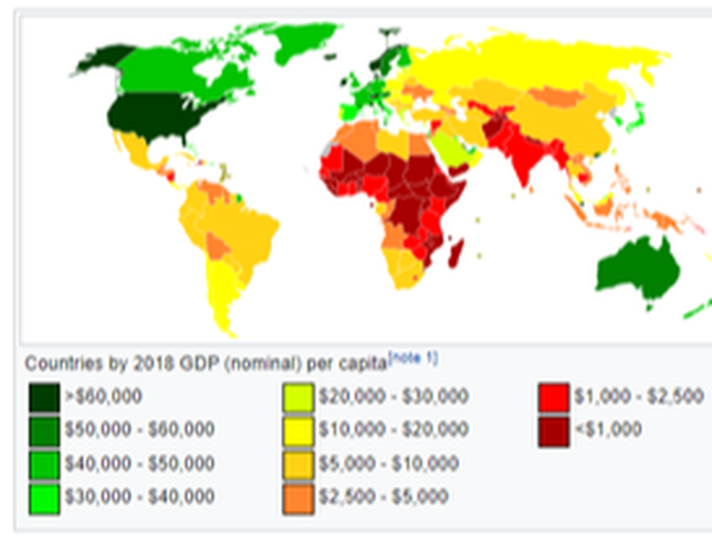
A developed country, industrialized country, more developed country, or more economically developed country (MEDC), is a sovereign state that has a developed economy and advanced technological infrastructure relative to other less industrialized nations.
Most commonly, the criteria for evaluating the degree of economic development are gross domestic product (GDP), gross national product (GNP), the per capita income, level of industrialization, amount of widespread infrastructure and general standard of living. Which criteria are to be used and which countries can be classified as being developed are subjects of debate.
Developed countries have generally more advanced post-industrial economies, meaning the service sector provides more wealth than the industrial sector. They are contrasted with developing countries, which are in the process of industrialisation or are pre-industrial and almost entirely agrarian, some of which might fall into the category of Least Developed Countries (Next).
As of 2015, advanced economies comprise 60.8% of global GDP based on nominal values and 42.9% of global GDP based on purchasing-power parity (PPP) according to the International Monetary Fund.
Click on any of the following blue hyperlinks for more about Developed Nations:
- Similar terms
- Definition and criteria
- Human Development Index (HDI)
- High-income economies
- Development Assistance Committee members
- IMF advanced economies
- Paris Club members
- Comparative table (2020)
- See also:
- Digital divide
- First World privilege
- First World problem
- Fourth World
- Globalization
- Group of Seven
- Group of Eight
- Multinational corporation
- Second World
- Third World
- List of countries by wealth per adult
- Western Bloc
- IMF (advanced economies)
- The Economist (quality of life survey)
- The World Factbook (developed countries)
- United Nations Statistics Division (definition)
- List of countries, United Nations Statistics Division (developed regions)
- World Bank (high-income economies)
Developing Countries
- YouTube Video: Where Are The World’s Worst Slums?
- YouTube Video: The most toxic place on earth - Agbogbloshie
- YouTube Video: Third World vs First World Countries - What's The Difference?
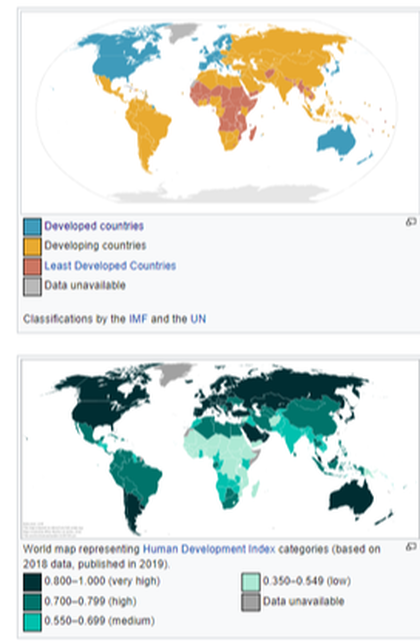
A developing country (or a low and middle income country (LMIC), less developed country, less economically developed country (LEDC), or underdeveloped country) is a country with a less developed industrial base and a low Human Development Index (HDI) relative to other countries.
However, this definition is not universally agreed upon. There is also no clear agreement on which countries fit this category. A nation's GDP per capita compared with other nations can also be a reference point. In general, the United Nations accepts any country's claim of itself being "developing".
There are controversies over the use of this term which some feel it is perpetuating an outdated concept of "us" and "them". In 2015, the World Bank declared that the "developing / developed world categorization" is becoming less relevant and that they will phase out the use of that descriptor. Instead, their reports with present data aggregations for regions, and for income groups.
The term "developing" describes a currently observed situation and not a changing dynamic or expected direction of progress. Since the late 1990s, developing countries tended to demonstrate higher growth rates than developed countries. Developing countries include, in decreasing order of economic growth or size of the capital market:
Therefore, the least developed countries are the poorest of the developing countries.
Developing countries tend to have some characteristics in common. For example, with regards to health risks, they commonly have low levels of:
Often, there is also widespread poverty, low education levels, inadequate access to family planning services, corruption at all government levels and a lack of so-called good governance. Effects of global warming (climate change) are expected to impact developing countries more than wealthier countries, as most of them have a high "climate vulnerability".
The Sustainable Development Goals by the United Nations were set up to help overcome many of these problems. Development aid or development cooperation is financial aid given by governments and other agencies to support the economic, environmental, social and political development of developing countries.
Click on any of the following blue hyperlinks for more about Developing Countries:
However, this definition is not universally agreed upon. There is also no clear agreement on which countries fit this category. A nation's GDP per capita compared with other nations can also be a reference point. In general, the United Nations accepts any country's claim of itself being "developing".
There are controversies over the use of this term which some feel it is perpetuating an outdated concept of "us" and "them". In 2015, the World Bank declared that the "developing / developed world categorization" is becoming less relevant and that they will phase out the use of that descriptor. Instead, their reports with present data aggregations for regions, and for income groups.
The term "developing" describes a currently observed situation and not a changing dynamic or expected direction of progress. Since the late 1990s, developing countries tended to demonstrate higher growth rates than developed countries. Developing countries include, in decreasing order of economic growth or size of the capital market:
Therefore, the least developed countries are the poorest of the developing countries.
Developing countries tend to have some characteristics in common. For example, with regards to health risks, they commonly have low levels of:
- access to safe drinking water,
- sanitation and hygiene;
- energy poverty;
- high levels of pollution (e.g.
- high proportion of people with tropical and infectious diseases (neglected tropical diseases);
- high number of road traffic accidents;
- and generally poor infrastructure.
Often, there is also widespread poverty, low education levels, inadequate access to family planning services, corruption at all government levels and a lack of so-called good governance. Effects of global warming (climate change) are expected to impact developing countries more than wealthier countries, as most of them have a high "climate vulnerability".
The Sustainable Development Goals by the United Nations were set up to help overcome many of these problems. Development aid or development cooperation is financial aid given by governments and other agencies to support the economic, environmental, social and political development of developing countries.
Click on any of the following blue hyperlinks for more about Developing Countries:
Cradle of Civilization
- YouTube Video about The Cradle(s) of Civilization
- YouTube Video: 1177 B.C.: When Civilization Collapsed | Eric Cline
- YouTube Video: Cradles of Civilization - The First Cities l Lessons of Dr. David Neiman
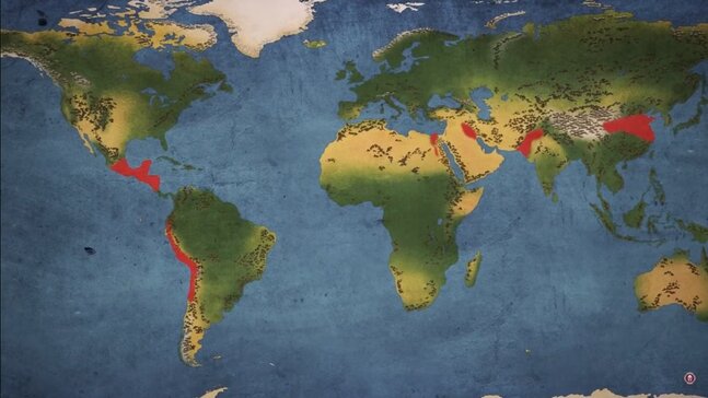
The cradle of civilization is any location where civilization is understood to have independently emerged.
According to current thinking, there was no single "cradle" of civilization; instead, several cradles of civilization developed independently: the following are believed to be the oldest in the Old World:
The extent to which there was significant influence between the early civilizations of the Near East and the Indus Valley with the Chinese civilization of East Asia (Far East) is disputed.
Scholars accept that the Olmec civilization of Mesoamerica, which existed in modern-day Mexico, and the civilization in Caral-Supe, a region in modern-day Peru, rival in age the civilizations of the Old World and emerged independently of the Old World and of each other.
Scholars have defined civilization by using various criteria such as the use of writing, cities, a class-based society, agriculture, animal husbandry, public buildings, metallurgy, and monumental architecture.
The term cradle of civilization has frequently been applied to a variety of regions and cultures, in particular to the Ancient Near East during the Chalcolithic (see Ubaid period), which contained the Fertile Crescent, and to Ancient India, and Ancient China. The term has also been applied to ancient Anatolia, the Levant, and the Iranian plateau, and is used to refer to cultural predecessors such as Ancient Greece, which is widely considered the predecessor to Western civilization.
History of the idea:
The concept "cradle of civilization" is the subject of much debate. The figurative use of cradle to mean "the place or region in which anything is nurtured or sheltered in its earlier stage" is traced by the Oxford English Dictionary to Spenser (1590).
Charles Rollin's Ancient History (1734) has "Egypt that served at first as the cradle of the holy nation".
The phrase "cradle of civilization" plays a certain role in national mysticism. It has been used in Eastern as well as Western cultures, for instance, in Indian nationalism (In Search of the Cradle of Civilization 1995) and Taiwanese nationalism (Taiwan;— The Cradle of Civilization 2002).
The terms also appear in esoteric pseudohistory, such as the Urantia Book, claiming the title for "the second Eden", or the pseudoarchaeology related to Megalithic Britain (Civilization One 2004, Ancient Britain: The Cradle of Civilization 1921).
Rise of civilization:
Further information: Neolithic Revolution, Urban revolution, and Chalcolithic
The earliest signs of a process leading to sedentary culture can be seen in the Levant to as early as 12,000 BC, when the Natufian culture became sedentary; it evolved into an agricultural society by 10,000 BC.
The importance of water to safeguard an abundant and stable food supply, due to favourable conditions for hunting, fishing and gathering resources including cereals, provided an initial wide spectrum economy that triggered the creation of permanent villages.
The earliest proto-urban settlements with several thousand inhabitants emerged in the Neolithic. The first cities to house several tens of thousands were Memphis and Uruk, by the 31st century BC (see Historical urban community sizes).
Historic times are marked apart from prehistoric times when "records of the past begin to be kept for the benefit of future generations"—in written or oral form.
If the rise of civilization is taken to coincide with the development of writing out of proto-writing, the Near Eastern Chalcolithic, the transitional period between the Neolithic and the Bronze Age during the 4th millennium BC, and the development of proto-writing in Harappa in the Indus Valley of South Asia around 3300 BC are the earliest incidences, followed by Chinese proto-writing evolving into the oracle bone script, and again by the emergence of Mesoamerican writing systems from about 900 BC.
In the absence of written documents, most aspects of the rise of early civilizations are contained in archaeological assessments that document the development of formal institutions and the material culture. A "civilized" way of life is ultimately linked to conditions coming almost exclusively from intensive agriculture.
Gordon Childe defined the development of civilization as the result of two successive revolutions: the Neolithic Revolution, triggering the development of settled communities, and the Urban Revolution, which enhanced tendencies towards dense settlements, specialized occupational groups, social classes, exploitation of surpluses, monumental public buildings and writing.
Few of those conditions, however, are unchallenged by the records: dense cities were not attested in Egypt's Old Kingdom and cities had a dispersed population in the Maya area; the Incas lacked writing although they could keep records with Quipus which might also have had literary uses; and often monumental architecture preceded any indication of village settlement.
For instance, in present-day Louisiana, researchers have determined that cultures that were primarily nomadic organized over generations to build earthwork mounds at seasonal settlements as early as 3400 BC. Rather than a succession of events and preconditions, the rise of civilization could equally be hypothesized as an accelerated process that started with incipient agriculture and culminated in the Oriental Bronze Age.
Single or multiple cradles:
A traditional theory of the spread of civilization is that it began in the Fertile Crescent and spread out from there by influence. Scholars more generally now believe that civilizations arose independently at several locations in both hemispheres. They have observed that sociocultural developments occurred along different timeframes. "Sedentary" and "nomadic" communities continued to interact considerably; they were not strictly divided among widely different cultural groups.
The concept of a cradle of civilization has a focus where the inhabitants came to build cities, to create writing systems, to experiment in techniques for making pottery and using metals, to domesticate animals, and to develop complex social structures involving class systems.
Current scholarship generally identifies six sites where civilization emerged independently:
A question that intrigues scholars is why pristine civilizations rose when and where they did. The economies of all of the pristine civilizations depended upon agriculture, with the possible exception of the Andean coast civilization which may have initially relied as much or more on marine resources.
Jared Diamond postulates that the reason the Fertile Crescent was the earliest civilization was that large-seeded, easily-domesticable plants (wheat and barley, among others) and large domesticable animals (cattle, pigs, sheep, horses) were native to the region.
By contrast, it took thousands of years of selective breeding in Mesoamerica for maize to become productive enough to be a staple crop. Mesoamerica also lacked large domesticable animals. Llamas were the only large, domesticable animal in the Andes of South America. Llamas are large enough to be pack animals but not large enough to be ridden or as draft animals.
Australia lacked both easily domesticable plants and large animals.
Cradles of civilization:
Fertile Crescent:
Mesopotamia:
Main articles: History of Mesopotamia, History of Sumer, and Sumer
Around 10,200 BC the first fully developed Neolithic cultures belonging to the phases Pre-Pottery Neolithic A (PPNA) and Pre-Pottery Neolithic B (7600 to 6000 BC) appeared in the Fertile Crescent and from there spread eastward and westward.
One of the most notable PPNA settlements is Jericho in the Levant region, thought to be the world's first town (settled around 9600 BC and fortified around 6800 BC).
In Mesopotamia, the convergence of the Tigris and Euphrates rivers produced rich fertile soil and a supply of water for irrigation. The civilizations that emerged around these rivers are among the earliest known non-nomadic agrarian societies. It is because of this that the Fertile Crescent region, and Mesopotamia in particular, are often referred to as the cradle of civilization.
The period known as the Ubaid period (c. 6500 to 3800 BC) is the earliest known period on the alluvial plain, although it is likely earlier periods exist obscured under the alluvium. It was during the Ubaid period that the movement toward urbanization began.
Agriculture and animal husbandry were widely practiced in sedentary communities, particularly in Northern Mesopotamia, and intensive irrigated hydraulic agriculture began to be practiced in the south.
Around 6000 BC, Neolithic settlements appear all over Egypt. Studies based on morphological, genetic, and archaeological data have attributed these settlements to migrants from the Fertile Crescent in the Near East returning during the Egyptian and North African Neolithic Revolution and bringing agriculture to the region.
Tell el-'Oueili is the oldest Sumerian site settled during this period, around 5300 BC, and the city of Ur also first dates to the end of this period. In the south, the Ubaid period took place from around 6500 to 3800 BC, when it was replaced by the Uruk period.
Sumerian civilization coalesced in the subsequent Uruk period (4000 to 3100 BC). Named after the Sumerian city of Uruk, this period saw the emergence of urban life in Mesopotamia and, during its later phase, the gradual emergence of the cuneiform script.
Proto-writing in the region dates to around 3500 BC, with the earliest texts dating to 3300 BC; early cuneiform writing emerged in 3000 BC. It was also during this period that pottery painting declined as copper started to become popular, along with cylinder seals.
Sumerian cities during the Uruk period were probably theocratic and were most likely headed by a priest-king (ensi), assisted by a council of elders, including both men and women. It is quite possible that the later Sumerian pantheon was modeled upon this political structure.
Uruk trade networks started to expand to other parts of Mesopotamia and as far as North Caucasus, and strong signs of governmental organization and social stratification began to emerge leading to the Early Dynastic Period (c. 2900 BC).
The Jemdet Nasr period, which is generally dated from 3100 to 2900 BC and succeeds the Uruk period, is known as one of the formative stages in the development of the cuneiform script. The oldest clay tablets come from Uruk and date to the late fourth millennium BC, slightly earlier than the Jemdet Nasr Period.
By the time of the Jemdet Nasr Period, the script had already undergone a number of significant changes. It originally consisted of pictographs, but by the time of the Jemdet Nasr Period it was already adopting simpler and more abstract designs. It is also during this period that the script acquired its iconic wedge-shaped appearance.
After the Early Dynastic period begins, there was a shift in control of the city-states from the temple establishment headed by council of elders led by a priestly "En" (a male figure when it was a temple for a goddess, or a female figure when headed by a male god) towards a more secular Lugal (Lu = man, Gal = great) and includes such legendary patriarchal figures as Enmerkar, Lugalbanda and Gilgamesh—who are supposed to have reigned shortly before the historic record opens c. 2700 BC, when the now deciphered syllabic writing started to develop from the early pictograms.
The center of Sumerian culture remained in southern Mesopotamia, even though rulers soon began expanding into neighboring areas, and neighboring Semitic groups adopted much of Sumerian culture for their own. The earliest ziggurats began near the end of the Early Dynastic Period, although architectural precursors in the form of raised platforms date back to the Ubaid period.
The well-known Sumerian King List dates to the early second millennium BC. It consists of a succession of royal dynasties from different Sumerian cities, ranging back into the Early Dynastic Period. Each dynasty rises to prominence and dominates the region, only to be replaced by the next. The document was used by later Mesopotamian kings to legitimize their rule. While some of the information in the list can be checked against other texts such as economic documents, much of it is probably purely fictional, and its use as a historical document is limited.
Eannatum, the Sumerian king of Lagash, established one of the first verifiable empires in history in 2500 BC. The neighboring Elam, in modern Iran, was also part of the early urbanization during the Chalcolithic period. Elamite states were among the leading political forces of the Ancient Near East.
The emergence of Elamite written records from around 3000 BC also parallels Sumerian history, where slightly earlier records have been found. During the 3rd millennium BC, there developed a very intimate cultural symbiosis between the Sumerians and the Akkadians.
Akkadian gradually replaced Sumerian as a spoken language somewhere between the 3rd and the 2nd millennia BC. The Semitic-speaking Akkadian empire emerged around 2350 BC under Sargon the Great. The Akkadian Empire reached its political peak between the 24th and 22nd centuries BC.
Under Sargon and his successors, the Akkadian language was briefly imposed on neighboring conquered states such as Elam and Gutium. After the fall of the Akkadian Empire and the overthrow of the Gutians, there was a brief reassertion of Sumerian dominance in Mesopotamia under the Third Dynasty of Ur.
After the final collapse of Sumerian hegemony in Mesopotamia around 2004 BC, the Semitic Akkadian people of Mesopotamia eventually coalesced into two major Akkadian-speaking nations: Assyria in the north, and, a few centuries later, Babylonia in the south.
Ancient Egypt:
Main articles: History of ancient Egypt and Ancient Egypt
The developed Neolithic cultures belonging to the phases Pre-Pottery Neolithic A (10,200 BC) and Pre-Pottery Neolithic B (7600 to 6000 BC) appeared in the fertile crescent and from there spread eastwards and westwards. Contemporaneously, a grain-grinding culture using the earliest type of sickle blades had replaced the culture of hunters, fishers, and gathering people using stone tools along the Nile.
Geological evidence and computer climate modeling studies also suggest that natural climate changes around 8000 BC began to desiccate the extensive pastoral lands of northern Africa, eventually forming the Sahara. Continued desiccation forced the early ancestors of the Egyptians to settle around the Nile more permanently and to adopt a more sedentary lifestyle. The oldest fully developed neolithic culture in Egypt is Fayum A culture that began around 5500 B.C.
By about 5500 BC, small tribes living in the Nile valley had developed into a series of inter-related cultures as far south as Sudan, demonstrating firm control of agriculture and animal husbandry, and identifiable by their pottery and personal items, such as combs, bracelets, and beads.
The largest of these early cultures in upper Southern Egypt was the Badari, which probably originated in the Western Desert; it was known for its high quality ceramics, stone tools, and use of copper. The oldest known domesticated bovine in Africa are from Fayum dating to around 4400 BC.
The Badari cultures was followed by the Naqada culture, which brought a number of technological improvements. As early as the first Naqada Period, Amratia, Egyptians imported obsidian from Ethiopia, used to shape blades and other objects from flakes. By 3300 BC, just before the first Egyptian dynasty, Egypt was divided into two kingdoms, known as Upper Egypt to the south, and Lower Egypt to the north.
Egyptian civilization begins during the second phase of the Naqda culture, known as the Gerzeh period, around 3500 BC and coalesces with the unification of Upper and Lower Egypt around 3150 BC. Farming produced the vast majority of food; with increased food supplies, the populace adopted a much more sedentary lifestyle, and the larger settlements grew to cities of about 5,000 residents.
It was in this time that the city dwellers started using mud brick to build their cities, and the use of the arch and recessed walls for decorative effect became popular. Copper instead of stone was increasingly used to make tools and weaponry. Symbols on Gerzean pottery also resemble nascent Egyptian hieroglyphs. Early evidence also exists of contact with the Near East, particularly Canaan and the Byblos coast, during this time.
Concurrent with these cultural advances, a process of unification of the societies and towns of the upper Nile River, or Upper Egypt, occurred. At the same time the societies of the Nile Delta, or Lower Egypt, also underwent a unification process. During his reign in Upper Egypt, King Narmer defeated his enemies on the Delta and merged both the Kingdom of Upper and Lower Egypt under his single rule.
The Early Dynastic Period of Egypt immediately followed the unification of Upper and Lower Egypt. It is generally taken to include the First and Second Dynasties, lasting from the Naqada III archaeological period until about the beginning of the Old Kingdom, c. 2686 BC. With the First Dynasty, the capital moved from Thinis to Memphis with a unified Egypt ruled by a god-king.
The hallmarks of ancient Egyptian civilization, such as art, architecture and many aspects of religion, took shape during the Early Dynastic period. The strong institution of kingship developed by the pharaohs served to legitimize state control over the land, labour, and resources that were essential to the survival and growth of ancient Egyptian civilization.
Major advances in architecture, art, and technology were made during the subsequent Old Kingdom, fueled by the increased agricultural productivity and resulting population, made possible by a well-developed central administration. Some of ancient Egypt's crowning achievements, the Giza pyramids and Great Sphinx, were constructed during the Old Kingdom.
Under the direction of the vizier, state officials collected taxes, coordinated irrigation projects to improve crop yield, drafted peasants to work on construction projects, and established a justice system to maintain peace and order. Along with the rising importance of a central administration there arose a new class of educated scribes and officials who were granted estates by the pharaoh in payment for their services.
Pharaohs also made land grants to their mortuary cults and local temples, to ensure that these institutions had the resources to worship the pharaoh after his death. Scholars believe that five centuries of these practices slowly eroded the economic power of the pharaoh, and that the economy could no longer afford to support a large centralized administration.
As the power of the pharaoh diminished, regional governors called nomarchs began to challenge the supremacy of the pharaoh. This, coupled with severe droughts between 2200 and 2150 BC, is assumed to have caused the country to enter the 140-year period of famine and strife known as the First Intermediate Period.
Ancient India:
Main articles:
One of the earliest Neolithic sites in the Indian subcontinent is Bhirrana along the ancient Ghaggar-Hakra riverine system in the present day state of Haryana in India, dating to around 7600 BC. Other early sites include Lahuradewa in the Middle Ganges region and Jhusi near the confluence of Ganges and Yamuna rivers, both dating to around 7000 BC.
The aceramic Neolithic at Mehrgarh in present day Pakistan lasts from 7000 to 5500 BC, with the ceramic Neolithic at Mehrgarh lasting up to 3300 BC; blending into the Early Bronze Age. Mehrgarh is one of the earliest sites with evidence of farming and herding in the Indian subcontinent.
It is likely that the culture centered around Mehrgarh migrated into the Indus Valley in present day Pakistan and became the Indus Valley Civilisation. The earliest fortified town in the region is found at Rehman Dheri, dated 4000 BC in Khyber Pakhtunkhwa close to River Zhob Valley in present day Pakistan .
Other fortified towns found to date are at Amri (3600–3300 BC), Kot Diji in Sindh, and at Kalibangan (3000 BC) at the Hakra River.
The Indus Valley Civilisation starts around 3300 BC with what is referred to as the Early Harappan Phase (3300 to 2600 BC). The earliest examples of the Indus script date to this period, as well as the emergence of citadels representing centralised authority and an increasingly urban quality of life.
Trade networks linked this culture with related regional cultures and distant sources of raw materials, including lapis lazuli and other materials for bead-making. By this time, villagers had domesticated numerous crops, including peas, sesame seeds, dates, and cotton, as well as animals, including the water buffalo.
2600 BC marks the Mature Harappan Phase during which Early Harappan communities turned into large urban centres including Harappa, Dholavira, Mohenjo-Daro, Lothal, Rupar, and Rakhigarhi, and more than 1,000 towns and villages, often of relatively small size.
Mature Harappans evolved new techniques in metallurgy and produced copper, bronze, lead, and tin and displayed advanced levels of engineering. As seen in Harappa, Mohenjo-daro and the recently partially excavated Rakhigarhi, this urban plan included the world's first known urban sanitation systems: see hydraulic engineering of the Indus Valley Civilisation.
Within the city, individual homes or groups of homes obtained water from wells. From a room that appears to have been set aside for bathing, waste water was directed to covered drains, which lined the major streets. Houses opened only to inner courtyards and smaller lanes. The house-building in some villages in the region still resembles in some respects the house-building of the Harappans.
The advanced architecture of the Harappans is shown by their impressive dockyards, granaries, warehouses, brick platforms, and protective walls. The massive walls of Indus cities most likely protected the Harappans from floods and may have dissuaded military conflicts.
The people of the Indus Civilisation achieved great accuracy in measuring length, mass, and time. They were among the first to develop a system of uniform weights and measures. A comparison of available objects indicates large scale variation across the Indus territories.
Their smallest division, which is marked on an ivory scale found in Lothal in Gujarat, was approximately 1.704 mm, the smallest division ever recorded on a scale of the Bronze Age. Harappan engineers followed the decimal division of measurement for all practical purposes, including the measurement of mass as revealed by their hexahedron weights.
These chert weights were in a ratio of 5:2:1 with weights of 0.05, 0.1, 0.2, 0.5, 1, 2, 5, 10, 20, 50, 100, 200, and 500 units, with each unit weighing approximately 28 grams, similar to the English Imperial ounce or Greek uncia, and smaller objects were weighed in similar ratios with the units of 0.871. However, as in other cultures, actual weights were not uniform throughout the area. The weights and measures later used in Kautilya's Arthashastra (4th century BC) are the same as those used in Lothal.
Around 1800 BC, signs of a gradual decline began to emerge, and by around 1700 BC most of the cities had been abandoned. Suggested contributory causes for the localisation of the IVC include changes in the course of the river, and climate change that is also signalled for the neighbouring areas of the Middle East.
As of 2016 many scholars believe that drought led to a decline in trade with Egypt and Mesopotamia contributing to the collapse of the Indus Civilisation. The Ghaggar-Hakra system was rain-fed, and water-supply depended on the monsoons. The Indus Valley climate grew significantly cooler and drier from about 1800 BC, linked to a general weakening of the monsoon at that time.
The Indian monsoon declined and aridity increased, with the Ghaggar-Hakra retracting its reach towards the foothills of the Himalaya, leading to erratic and less extensive floods that made inundation agriculture less sustainable. Aridification reduced the water supply enough to cause the civilisation's demise, and to scatter its population eastward. As the monsoons kept shifting south, the floods grew too erratic for sustainable agricultural activities. The residents then migrated away into smaller communities.
However trade with the old cities did not flourish. The small surplus produced in these small communities did not allow development of trade, and the cities died out. The Indo-Aryan peoples migrated into the Indus River Valley during this period and began the Vedic age of India. The Indus Valley Civilisation did not disappear suddenly and many elements of the civilization continued in later Indian subcontinent and Vedic cultures.
Ancient China:
Main articles: History of China, Xia dynasty, and Erlitou culture
Drawing on archaeology, geology and anthropology, modern scholars do not see the origins of the Chinese civilization or history as a linear story but rather the history of the interactions of different and distinct cultures and ethnic groups that influenced each other's development.
The specific cultural regions that developed Chinese civilization were the Yellow River civilization, the Yangtze civilization, and Liao civilization. Early evidence for Chinese millet agriculture is dated to around 7000 BC, with the earliest evidence of cultivated rice found at Chengtoushan near the Yangtze River, dated to 6500 BC.
Chengtoushan may also be the site of the first walled city in China. By the beginning of the Neolithic Revolution, the Yellow River valley began to establish itself as a center of the Peiligang culture, which flourished from 7000 to 5000 BC, with evidence of agriculture, constructed buildings, pottery, and burial of the dead.
With agriculture came increased population, the ability to store and redistribute crops, and the potential to support specialist craftsmen and administrators. Its most prominent site is Jiahu.
Some scholars have suggested that the Jiahu symbols (6600 BC) are the earliest form of proto-writing in China. However, it is likely that they should not be understood as writing itself, but as features of a lengthy period of sign-use, which led eventually to a fully-fledged system of writing. Archaeologists believe that the Peiligang culture was egalitarian, with little political organization.
It eventually evolved into the Yangshao culture (5000 to 3000 BC), and their stone tools were polished and highly specialized. They may also have practiced an early form of silkworm cultivation. The main food of the Yangshao people was millet, with some sites using foxtail millet and others broom-corn millet, though some evidence of rice has been found.
The exact nature of Yangshao agriculture, small-scale slash-and-burn cultivation versus intensive agriculture in permanent fields, is currently a matter of debate. Once the soil was exhausted, residents picked up their belongings, moved to new lands, and constructed new villages.
However, Middle Yangshao settlements such as Jiangzhi contain raised-floor buildings that may have been used for the storage of surplus grains. Grinding stones for making flour were also found.
Later, Yangshao culture was superseded by the Longshan culture, which was also centered on the Yellow River from about 3000 to 1900 BC, its most prominent site being Taosi. The population expanded dramatically during the 3rd millennium BC, with many settlements having rammed earth walls. It decreased in most areas around 2000 BC until the central area evolved into the Bronze Age Erlitou culture.
The earliest bronze artifacts have been found in the Majiayao culture site (3100 to 2700 BC).
Chinese civilization begins during the second phase of the Erlitou period (1900 to 1500 BC), with Erlitou considered the first state level society of East Asia. There is considerable debate whether Erlitou sites correlate to the semi-legendary Xia dynasty. The Xia dynasty (2070 to 1600 BC) is the first dynasty to be described in ancient Chinese historical records such as the Bamboo Annals, first published more than a millennium later during the Western Zhou period.
Although Xia is an important element in Chinese historiography, there is to date no contemporary written evidence to corroborate the dynasty. Erlitou saw an increase in bronze metallurgy and urbanization and was a rapidly growing regional center with palatial complexes that provide evidence for social stratification.
The Erlitou civilization is divided into four phases, each of roughly 50 years. During Phase I, covering 100 hectares (250 acres), Erlitou was a rapidly growing regional center with estimated population of several thousand but not yet an urban civilization or capital.
Urbanization began in Phase II, expanding to 300 ha (740 acres) with a population around 11,000. A palace area of 12 ha (30 acres) was demarcated by four roads. It contained the 150x50 m Palace 3, composed of three courtyards along a 150-meter axis, and Palace 5. A bronze foundry was established to the south of the palatial complex that was controlled by the elite who lived in palaces.
The city reached its peak in Phase III, and may have had a population of around 24,000. The palatial complex was surrounded by a two-meter-thick rammed-earth wall, and Palaces 1, 7, 8, 9 were built. The earthwork volume of rammed earth for the base of largest Palace 1 is 20,000 m³ at least. Palaces 3 and 5 were abandoned and replaced by 4,200-square-meter (45,000 sq ft) Palace 2 and Palace 4.
In Phase IV, the population decreased to around 20,000, but building continued. Palace 6 was built as an extension of Palace 2, and Palaces 10 and 11 were built. Phase IV overlaps with the Lower phase of the Erligang culture (1600–1450 BC).
Around 1600 to 1560 BC, about 6 km northeast of Erlitou, a culturally Eligang walled city was built at Yanshi, which coincides with an increase in production of arrowheads at Erlitou. This situation might indicate that the Yanshi city was competing for power and dominance with Erlitou.
Production of bronzes and other elite goods ceased at the end of Phase IV, at the same time as the Erligang city of Zhengzhou was established 85 km (53 mi) to the east. There is no evidence of destruction by fire or war, but, during the Upper Erligang phase (1450–1300 BC), all the palaces were abandoned, and Erlitou was reduced to a village of 30 ha (74 acres).
The earliest traditional Chinese dynasty for which there is both archeological and written evidence is the Shang dynasty (1600 to 1046 BC). Shang sites have yielded the earliest known body of Chinese writing, the oracle bone script, mostly divinations inscribed on bones. These inscriptions provide critical insight into many topics from the politics, economy, and religious practices to the art and medicine of this early stage of Chinese civilization.
Some historians argue that Erlitou should be considered an early phase of the Shang dynasty. The U.S. National Gallery of Art defines the Chinese Bronze Age as the period between about 2000 and 771 BC; a period that begins with the Erlitou culture and ends abruptly with the disintegration of Western Zhou rule. The Sanxingdui culture is another Chinese Bronze Age society, contemporaneous to the Shang dynasty, however they developed a different method of bronze-making from the Shang.
Ancient Andes:
Main article: Norte Chico civilization
The earliest evidence of agriculture in the Andean region dates to around 9000 BC in Ecuador at sites of the Las Vegas Culture. The bottle gourd may have been the first plant cultivated. The oldest evidence of canal irrigation in South America dates to 4700 to 2500 BC in the Zaña Valley of northern Peru. The earliest urban settlements of the Andes, as well as North and South America, are dated to 3500 BC at Huaricanga, in the Fortaleza area, and Sechin Bajo near the Sechin River. Both sites are in Peru.
The Norte Chico civilization proper is understood to have emerged around 3200 BC, as it is at that point that large-scale human settlement and communal construction across multiple sites becomes clearly apparent. Since the early 21st century, it has been established as the oldest known civilization in the Americas.
The civilization flourished near the Pacific coast in the valleys of three small rivers, the Fortaleza, the Pativilca, and the Supe. These river valleys each have large clusters of sites.
Further south, there are several associated sites along the Huaura River. Notable settlements include the cities of Caral, the largest and most complex Preceramic site, and Aspero.
Norte Chico sites are known for their density of large sites with immense architecture. Haas argues that the density of sites in such a small area is globally unique for a nascent civilization. During the third millennium BC, Norte Chico may have been the most densely populated area of the world (excepting, possibly, northern China). The Supe, Pativilca, Fortaleza, and Huaura River valleys each have several related sites.
Norte Chico is unusual in that it completely lacked ceramics and apparently had almost no visual art. Nevertheless, the civilization exhibited impressive architectural feats, including large earthwork platform mounds and sunken circular plazas, and an advanced textile industry. The platform mounds, as well as large stone warehouses, provide evidence for a stratified society and a centralized authority necessary to distribute resources such as cotton.
However, there is no evidence of warfare or defensive structures during this period. Originally, it was theorized that, unlike other early civilizations, Norte Chico developed by relying on maritime food sources in place of a staple cereal. This hypothesis, the Maritime Foundation of Andean Civilization, is still hotly debated; however, most researches now agree that agriculture played a central role in the civilization's development while still acknowledging a strong supplemental reliance on maritime proteins.
The Norte Chico chiefdoms were "...almost certainly theocratic, though not brutally so," according to Mann. Construction areas show possible evidence of feasting, which would have included music and likely alcohol, suggesting an elite able to both mobilize and reward the population.
The degree of centralized authority is difficult to ascertain, but architectural construction patterns are indicative of an elite that, at least in certain places at certain times, wielded considerable power: while some of the monumental architecture was constructed incrementally, other buildings, such as the two main platform mounds at Caral, appear to have been constructed in one or two intense construction phases.
As further evidence of centralized control, Haas points to remains of large stone warehouses found at Upaca, on the Pativilca, as emblematic of authorities able to control vital resources such as cotton. Economic authority would have rested on the control of cotton and edible plants and associated trade relationships, with power centered on the inland sites.
Haas tentatively suggests that the scope of this economic power base may have extended widely: there are only two confirmed shore sites in the Norte Chico (Aspero and Bandurria) and possibly two more, but cotton fishing nets and domesticated plants have been found up and down the Peruvian coast. It is possible that the major inland centers of Norte Chico were at the center of a broad regional trade network centered on these resources.
Discover magazine, citing Shady, suggests a rich and varied trade life: "[Caral] exported its own products and those of Aspero to distant communities in exchange for exotic imports: Spondylus shells from the coast of Ecuador, rich dyes from the Andean highlands, hallucinogenic snuff from the Amazon." (Given the still limited extent of Norte Chico research, such claims should be treated circumspectly.)
Other reports on Shady's work indicate Caral traded with communities in the Andes and in the jungles of the Amazon basin on the opposite side of the Andes.
Leaders' ideological power was based on apparent access to deities and the supernatural. Evidence regarding Norte Chico religion is limited: an image of the Staff God, a leering figure with a hood and fangs, has been found on a gourd dated to 2250 BC.
The Staff God is a major deity of later Andean cultures, and Winifred Creamer suggests the find points to worship of common symbols of gods. As with much other research at Norte Chico, the nature and significance of the find has been disputed by other researchers.
The act of architectural construction and maintenance may also have been a spiritual or religious experience: a process of communal exaltation and ceremony. Shady has called Caral "the sacred city" (la ciudad sagrada): socio-economic and political focus was on the temples, which were periodically remodeled, with major burnt offerings associated with the remodeling.
The discovery of quipu, string-based recording devices, at Caral can be understood as a form of "proto-writing" at Norte Chico. However, the exact use of quipu in this and later Andean cultures has been widely debated. The presence of quipu and the commonality of religious symbols suggests a cultural link between Norte Chico and later Andean cultures.
Circa 1800 BC, the Norte Chico civilization began to decline, with more powerful centers appearing to the south and north along the coast and to the east inside the belt of the Andes. Pottery eventually developed in the Amazon Basin and spread to the Andean culture region around 2000 BC.
The next major civilization to arise in the Andes would be the Chavín culture at Chavín de Huantar, located in the Andean highlands of the present-day Ancash Region. It is believed to have been built around 900 BC and was the religious and political center of the Chavín people.
Mesoamerica:
Main articles: Mesoamerican chronology and Olmec civilization
Maize is believed to have been first domesticated in southern Mexico about 7000 BC. The Coxcatlan caves in the Valley of Tehuacán provide evidence for agriculture in components dated between 5000 and 3400 BC.
Similarly, sites such as Sipacate in Guatemala provide maize pollen samples dating to 3500 BC. Around 1900 BC, the Mokaya domesticated one of the dozen species of cacao. A Mokaya archaeological site provides evidence of cacao beverages dating to this time. The Mokaya are also thought to have been among the first cultures in Mesoamerica to develop a hierarchical society. What would become the Olmec civilization had its roots in early farming cultures of Tabasco, which began around 5100 to 4600 BC.
The emergence of the Olmec civilization has traditionally been dated to around 1600 to 1500 BC. Olmec features first emerged in the city of San Lorenzo Tenochtitlán, fully coalescing around 1400 BC. The rise of civilization was assisted by the local ecology of well-watered alluvial soil, as well as by the transportation network provided by the Coatzacoalcos River basin.
This environment encouraged a densely concentrated population, which in turn triggered the rise of an elite class and an associated demand for the production of the symbolic and sophisticated luxury artifacts that define Olmec culture. Many of these luxury artifacts were made from materials such as jade, obsidian, and magnetite, which came from distant locations and suggest that early Olmec elites had access to an extensive trading network in Mesoamerica.
The aspect of Olmec culture perhaps most familiar today is their artwork, particularly the Olmec colossal heads. San Lorenzo was situated in the midst of a large agricultural area. San Lorenzo seems to have been largely a ceremonial site, a town without city walls, centered in the midst of a widespread medium-to-large agricultural population.
The ceremonial center and attendant buildings could have housed 5,500 while the entire area, including hinterlands, could have reached 13,000. It is thought that while San Lorenzo controlled much or all of the Coatzacoalcos basin, areas to the east (such as the area where La Venta would rise to prominence) and north-northwest (such as the Tuxtla Mountains) were home to independent polities.
San Lorenzo was all but abandoned around 900 BC at about the same time that La Venta rose to prominence. A wholesale destruction of many San Lorenzo monuments also occurred circa 950 BC, which may indicate an internal uprising or, less likely, an invasion.
The latest thinking, however, is that environmental changes may have been responsible for this shift in Olmec centers, with certain important rivers changing course.
La Venta became the cultural capital of the Olmec concentration in the region until its abandonment around 400 BC; constructing monumental architectural achievements such as the Great Pyramid of La Venta. It contained a "concentration of power", as reflected by the sheer enormity of the architecture and the extreme value of the artifacts uncovered.
La Venta is perhaps the largest Olmec city and it was controlled and expanded by an extremely complex hierarchical system with a king, as the ruler and the elites below him. Priests had power and influence over life and death and likely great political sway as well.
Unfortunately, not much is known about the political or social structure of the Olmec, though new dating techniques might, at some point, reveal more information about this elusive culture. It is possible that the signs of status exist in the artifacts recovered at the site such as depictions of feathered headdresses or of individuals wearing a mirror on their chest or forehead.
"High-status objects were a significant source of power in the La Venta polity political power, economic power, and ideological power. They were tools used by the elite to enhance and maintain rights to rulership".
It has been estimated that La Venta would need to be supported by a population of at least 18,000 people during its principal occupation. To add to the mystique of La Venta, the alluvial soil did not preserve skeletal remains, so it is difficult to observe differences in burials.
However, colossal heads provide proof that the elite had some control over the lower classes, as their construction would have been extremely labor-intensive. "Other features similarly indicate that many laborers were involved". In addition, excavations over the years have discovered that different parts of the site were likely reserved for elites and other parts for non-elites. This segregation of the city indicates that there must have been social classes and therefore social inequality.
The exact cause of the decline of the Olmec culture is uncertain. Between 400 and 350 BC, the population in the eastern half of the Olmec heartland dropped precipitously. This depopulation was probably the result of serious environmental changes that rendered the region unsuited for large groups of farmers, in particular changes to the riverine environment that the Olmec depended upon for agriculture, hunting and gathering, and transportation.
These changes may have been triggered by tectonic upheavals or subsidence, or the silting up of rivers due to agricultural practices. Within a few hundred years of the abandonment of the last Olmec cities, successor cultures became firmly established. The Tres Zapotes site, on the western edge of the Olmec heartland, continued to be occupied well past 400 BC, but without the hallmarks of the Olmec culture. This post-Olmec culture, often labeled Epi-Olmec, has features similar to those found at Izapa, some 550 km (330 miles) to the southeast.
The Olmecs are sometimes referred to as the mother culture of Mesoamerica, as they were the first Mesoamerican civilization and laid many of the foundations for the civilizations that followed. However, the causes and degree of Olmec influences on Mesoamerican cultures has been a subject of debate over many decades.
Practices introduced by the Olmec include ritual bloodletting and the Mesoamerican ballgame; hallmarks of subsequent Mesoamerican societies such as the Maya and Aztec. Although the Mesoamerican writing system would fully develop later, early Olmec ceramics show representations that may be interpreted as codices.
Cradle of Western civilization:
Main articles below:
There is academic consensus that Classical Greece was the seminal culture that provided the foundation of modern Western culture, democracy, art, theatre, philosophy, and science. For this reason it is known as the cradle of Western Civilization.
Along with Greece, Rome has sometimes been described as a birthplace or as the cradle of Western Civilization because of the role the city had in politics, republicanism, law, architecture, warfare and Western Christianity.
Timeline:
The following timeline shows a timeline of cultures, with the approximate dates of the emergence of civilization (as discussed in the article) in the featured areas, the primary cultures associated with these early civilizations.
It is important to note that the timeline is not indicative of the beginning of human habitation, the start of a specific ethnic group, or the development of Neolithic cultures in the area – any of which often occurred significantly earlier than the emergence of civilization proper.
In the case of the Indus Valley Civilization, this was followed by a period of de-urbanization and regionalisation, and the co-existence of indigenous local agricultural cultures and the pastoral Indo-Aryans, who came from Central Asia.
According to current thinking, there was no single "cradle" of civilization; instead, several cradles of civilization developed independently: the following are believed to be the oldest in the Old World:
The extent to which there was significant influence between the early civilizations of the Near East and the Indus Valley with the Chinese civilization of East Asia (Far East) is disputed.
Scholars accept that the Olmec civilization of Mesoamerica, which existed in modern-day Mexico, and the civilization in Caral-Supe, a region in modern-day Peru, rival in age the civilizations of the Old World and emerged independently of the Old World and of each other.
Scholars have defined civilization by using various criteria such as the use of writing, cities, a class-based society, agriculture, animal husbandry, public buildings, metallurgy, and monumental architecture.
The term cradle of civilization has frequently been applied to a variety of regions and cultures, in particular to the Ancient Near East during the Chalcolithic (see Ubaid period), which contained the Fertile Crescent, and to Ancient India, and Ancient China. The term has also been applied to ancient Anatolia, the Levant, and the Iranian plateau, and is used to refer to cultural predecessors such as Ancient Greece, which is widely considered the predecessor to Western civilization.
History of the idea:
The concept "cradle of civilization" is the subject of much debate. The figurative use of cradle to mean "the place or region in which anything is nurtured or sheltered in its earlier stage" is traced by the Oxford English Dictionary to Spenser (1590).
Charles Rollin's Ancient History (1734) has "Egypt that served at first as the cradle of the holy nation".
The phrase "cradle of civilization" plays a certain role in national mysticism. It has been used in Eastern as well as Western cultures, for instance, in Indian nationalism (In Search of the Cradle of Civilization 1995) and Taiwanese nationalism (Taiwan;— The Cradle of Civilization 2002).
The terms also appear in esoteric pseudohistory, such as the Urantia Book, claiming the title for "the second Eden", or the pseudoarchaeology related to Megalithic Britain (Civilization One 2004, Ancient Britain: The Cradle of Civilization 1921).
Rise of civilization:
Further information: Neolithic Revolution, Urban revolution, and Chalcolithic
The earliest signs of a process leading to sedentary culture can be seen in the Levant to as early as 12,000 BC, when the Natufian culture became sedentary; it evolved into an agricultural society by 10,000 BC.
The importance of water to safeguard an abundant and stable food supply, due to favourable conditions for hunting, fishing and gathering resources including cereals, provided an initial wide spectrum economy that triggered the creation of permanent villages.
The earliest proto-urban settlements with several thousand inhabitants emerged in the Neolithic. The first cities to house several tens of thousands were Memphis and Uruk, by the 31st century BC (see Historical urban community sizes).
Historic times are marked apart from prehistoric times when "records of the past begin to be kept for the benefit of future generations"—in written or oral form.
If the rise of civilization is taken to coincide with the development of writing out of proto-writing, the Near Eastern Chalcolithic, the transitional period between the Neolithic and the Bronze Age during the 4th millennium BC, and the development of proto-writing in Harappa in the Indus Valley of South Asia around 3300 BC are the earliest incidences, followed by Chinese proto-writing evolving into the oracle bone script, and again by the emergence of Mesoamerican writing systems from about 900 BC.
In the absence of written documents, most aspects of the rise of early civilizations are contained in archaeological assessments that document the development of formal institutions and the material culture. A "civilized" way of life is ultimately linked to conditions coming almost exclusively from intensive agriculture.
Gordon Childe defined the development of civilization as the result of two successive revolutions: the Neolithic Revolution, triggering the development of settled communities, and the Urban Revolution, which enhanced tendencies towards dense settlements, specialized occupational groups, social classes, exploitation of surpluses, monumental public buildings and writing.
Few of those conditions, however, are unchallenged by the records: dense cities were not attested in Egypt's Old Kingdom and cities had a dispersed population in the Maya area; the Incas lacked writing although they could keep records with Quipus which might also have had literary uses; and often monumental architecture preceded any indication of village settlement.
For instance, in present-day Louisiana, researchers have determined that cultures that were primarily nomadic organized over generations to build earthwork mounds at seasonal settlements as early as 3400 BC. Rather than a succession of events and preconditions, the rise of civilization could equally be hypothesized as an accelerated process that started with incipient agriculture and culminated in the Oriental Bronze Age.
Single or multiple cradles:
A traditional theory of the spread of civilization is that it began in the Fertile Crescent and spread out from there by influence. Scholars more generally now believe that civilizations arose independently at several locations in both hemispheres. They have observed that sociocultural developments occurred along different timeframes. "Sedentary" and "nomadic" communities continued to interact considerably; they were not strictly divided among widely different cultural groups.
The concept of a cradle of civilization has a focus where the inhabitants came to build cities, to create writing systems, to experiment in techniques for making pottery and using metals, to domesticate animals, and to develop complex social structures involving class systems.
Current scholarship generally identifies six sites where civilization emerged independently:
- Fertile Crescent
- Tigris–Euphrates Valley
- Nile Valley
- Indo-Gangetic Plain
- North China Plain
- Andean Coast
- Mesoamerican Gulf Coast
A question that intrigues scholars is why pristine civilizations rose when and where they did. The economies of all of the pristine civilizations depended upon agriculture, with the possible exception of the Andean coast civilization which may have initially relied as much or more on marine resources.
Jared Diamond postulates that the reason the Fertile Crescent was the earliest civilization was that large-seeded, easily-domesticable plants (wheat and barley, among others) and large domesticable animals (cattle, pigs, sheep, horses) were native to the region.
By contrast, it took thousands of years of selective breeding in Mesoamerica for maize to become productive enough to be a staple crop. Mesoamerica also lacked large domesticable animals. Llamas were the only large, domesticable animal in the Andes of South America. Llamas are large enough to be pack animals but not large enough to be ridden or as draft animals.
Australia lacked both easily domesticable plants and large animals.
Cradles of civilization:
Fertile Crescent:
Mesopotamia:
Main articles: History of Mesopotamia, History of Sumer, and Sumer
Around 10,200 BC the first fully developed Neolithic cultures belonging to the phases Pre-Pottery Neolithic A (PPNA) and Pre-Pottery Neolithic B (7600 to 6000 BC) appeared in the Fertile Crescent and from there spread eastward and westward.
One of the most notable PPNA settlements is Jericho in the Levant region, thought to be the world's first town (settled around 9600 BC and fortified around 6800 BC).
In Mesopotamia, the convergence of the Tigris and Euphrates rivers produced rich fertile soil and a supply of water for irrigation. The civilizations that emerged around these rivers are among the earliest known non-nomadic agrarian societies. It is because of this that the Fertile Crescent region, and Mesopotamia in particular, are often referred to as the cradle of civilization.
The period known as the Ubaid period (c. 6500 to 3800 BC) is the earliest known period on the alluvial plain, although it is likely earlier periods exist obscured under the alluvium. It was during the Ubaid period that the movement toward urbanization began.
Agriculture and animal husbandry were widely practiced in sedentary communities, particularly in Northern Mesopotamia, and intensive irrigated hydraulic agriculture began to be practiced in the south.
Around 6000 BC, Neolithic settlements appear all over Egypt. Studies based on morphological, genetic, and archaeological data have attributed these settlements to migrants from the Fertile Crescent in the Near East returning during the Egyptian and North African Neolithic Revolution and bringing agriculture to the region.
Tell el-'Oueili is the oldest Sumerian site settled during this period, around 5300 BC, and the city of Ur also first dates to the end of this period. In the south, the Ubaid period took place from around 6500 to 3800 BC, when it was replaced by the Uruk period.
Sumerian civilization coalesced in the subsequent Uruk period (4000 to 3100 BC). Named after the Sumerian city of Uruk, this period saw the emergence of urban life in Mesopotamia and, during its later phase, the gradual emergence of the cuneiform script.
Proto-writing in the region dates to around 3500 BC, with the earliest texts dating to 3300 BC; early cuneiform writing emerged in 3000 BC. It was also during this period that pottery painting declined as copper started to become popular, along with cylinder seals.
Sumerian cities during the Uruk period were probably theocratic and were most likely headed by a priest-king (ensi), assisted by a council of elders, including both men and women. It is quite possible that the later Sumerian pantheon was modeled upon this political structure.
Uruk trade networks started to expand to other parts of Mesopotamia and as far as North Caucasus, and strong signs of governmental organization and social stratification began to emerge leading to the Early Dynastic Period (c. 2900 BC).
The Jemdet Nasr period, which is generally dated from 3100 to 2900 BC and succeeds the Uruk period, is known as one of the formative stages in the development of the cuneiform script. The oldest clay tablets come from Uruk and date to the late fourth millennium BC, slightly earlier than the Jemdet Nasr Period.
By the time of the Jemdet Nasr Period, the script had already undergone a number of significant changes. It originally consisted of pictographs, but by the time of the Jemdet Nasr Period it was already adopting simpler and more abstract designs. It is also during this period that the script acquired its iconic wedge-shaped appearance.
After the Early Dynastic period begins, there was a shift in control of the city-states from the temple establishment headed by council of elders led by a priestly "En" (a male figure when it was a temple for a goddess, or a female figure when headed by a male god) towards a more secular Lugal (Lu = man, Gal = great) and includes such legendary patriarchal figures as Enmerkar, Lugalbanda and Gilgamesh—who are supposed to have reigned shortly before the historic record opens c. 2700 BC, when the now deciphered syllabic writing started to develop from the early pictograms.
The center of Sumerian culture remained in southern Mesopotamia, even though rulers soon began expanding into neighboring areas, and neighboring Semitic groups adopted much of Sumerian culture for their own. The earliest ziggurats began near the end of the Early Dynastic Period, although architectural precursors in the form of raised platforms date back to the Ubaid period.
The well-known Sumerian King List dates to the early second millennium BC. It consists of a succession of royal dynasties from different Sumerian cities, ranging back into the Early Dynastic Period. Each dynasty rises to prominence and dominates the region, only to be replaced by the next. The document was used by later Mesopotamian kings to legitimize their rule. While some of the information in the list can be checked against other texts such as economic documents, much of it is probably purely fictional, and its use as a historical document is limited.
Eannatum, the Sumerian king of Lagash, established one of the first verifiable empires in history in 2500 BC. The neighboring Elam, in modern Iran, was also part of the early urbanization during the Chalcolithic period. Elamite states were among the leading political forces of the Ancient Near East.
The emergence of Elamite written records from around 3000 BC also parallels Sumerian history, where slightly earlier records have been found. During the 3rd millennium BC, there developed a very intimate cultural symbiosis between the Sumerians and the Akkadians.
Akkadian gradually replaced Sumerian as a spoken language somewhere between the 3rd and the 2nd millennia BC. The Semitic-speaking Akkadian empire emerged around 2350 BC under Sargon the Great. The Akkadian Empire reached its political peak between the 24th and 22nd centuries BC.
Under Sargon and his successors, the Akkadian language was briefly imposed on neighboring conquered states such as Elam and Gutium. After the fall of the Akkadian Empire and the overthrow of the Gutians, there was a brief reassertion of Sumerian dominance in Mesopotamia under the Third Dynasty of Ur.
After the final collapse of Sumerian hegemony in Mesopotamia around 2004 BC, the Semitic Akkadian people of Mesopotamia eventually coalesced into two major Akkadian-speaking nations: Assyria in the north, and, a few centuries later, Babylonia in the south.
Ancient Egypt:
Main articles: History of ancient Egypt and Ancient Egypt
The developed Neolithic cultures belonging to the phases Pre-Pottery Neolithic A (10,200 BC) and Pre-Pottery Neolithic B (7600 to 6000 BC) appeared in the fertile crescent and from there spread eastwards and westwards. Contemporaneously, a grain-grinding culture using the earliest type of sickle blades had replaced the culture of hunters, fishers, and gathering people using stone tools along the Nile.
Geological evidence and computer climate modeling studies also suggest that natural climate changes around 8000 BC began to desiccate the extensive pastoral lands of northern Africa, eventually forming the Sahara. Continued desiccation forced the early ancestors of the Egyptians to settle around the Nile more permanently and to adopt a more sedentary lifestyle. The oldest fully developed neolithic culture in Egypt is Fayum A culture that began around 5500 B.C.
By about 5500 BC, small tribes living in the Nile valley had developed into a series of inter-related cultures as far south as Sudan, demonstrating firm control of agriculture and animal husbandry, and identifiable by their pottery and personal items, such as combs, bracelets, and beads.
The largest of these early cultures in upper Southern Egypt was the Badari, which probably originated in the Western Desert; it was known for its high quality ceramics, stone tools, and use of copper. The oldest known domesticated bovine in Africa are from Fayum dating to around 4400 BC.
The Badari cultures was followed by the Naqada culture, which brought a number of technological improvements. As early as the first Naqada Period, Amratia, Egyptians imported obsidian from Ethiopia, used to shape blades and other objects from flakes. By 3300 BC, just before the first Egyptian dynasty, Egypt was divided into two kingdoms, known as Upper Egypt to the south, and Lower Egypt to the north.
Egyptian civilization begins during the second phase of the Naqda culture, known as the Gerzeh period, around 3500 BC and coalesces with the unification of Upper and Lower Egypt around 3150 BC. Farming produced the vast majority of food; with increased food supplies, the populace adopted a much more sedentary lifestyle, and the larger settlements grew to cities of about 5,000 residents.
It was in this time that the city dwellers started using mud brick to build their cities, and the use of the arch and recessed walls for decorative effect became popular. Copper instead of stone was increasingly used to make tools and weaponry. Symbols on Gerzean pottery also resemble nascent Egyptian hieroglyphs. Early evidence also exists of contact with the Near East, particularly Canaan and the Byblos coast, during this time.
Concurrent with these cultural advances, a process of unification of the societies and towns of the upper Nile River, or Upper Egypt, occurred. At the same time the societies of the Nile Delta, or Lower Egypt, also underwent a unification process. During his reign in Upper Egypt, King Narmer defeated his enemies on the Delta and merged both the Kingdom of Upper and Lower Egypt under his single rule.
The Early Dynastic Period of Egypt immediately followed the unification of Upper and Lower Egypt. It is generally taken to include the First and Second Dynasties, lasting from the Naqada III archaeological period until about the beginning of the Old Kingdom, c. 2686 BC. With the First Dynasty, the capital moved from Thinis to Memphis with a unified Egypt ruled by a god-king.
The hallmarks of ancient Egyptian civilization, such as art, architecture and many aspects of religion, took shape during the Early Dynastic period. The strong institution of kingship developed by the pharaohs served to legitimize state control over the land, labour, and resources that were essential to the survival and growth of ancient Egyptian civilization.
Major advances in architecture, art, and technology were made during the subsequent Old Kingdom, fueled by the increased agricultural productivity and resulting population, made possible by a well-developed central administration. Some of ancient Egypt's crowning achievements, the Giza pyramids and Great Sphinx, were constructed during the Old Kingdom.
Under the direction of the vizier, state officials collected taxes, coordinated irrigation projects to improve crop yield, drafted peasants to work on construction projects, and established a justice system to maintain peace and order. Along with the rising importance of a central administration there arose a new class of educated scribes and officials who were granted estates by the pharaoh in payment for their services.
Pharaohs also made land grants to their mortuary cults and local temples, to ensure that these institutions had the resources to worship the pharaoh after his death. Scholars believe that five centuries of these practices slowly eroded the economic power of the pharaoh, and that the economy could no longer afford to support a large centralized administration.
As the power of the pharaoh diminished, regional governors called nomarchs began to challenge the supremacy of the pharaoh. This, coupled with severe droughts between 2200 and 2150 BC, is assumed to have caused the country to enter the 140-year period of famine and strife known as the First Intermediate Period.
Ancient India:
Main articles:
One of the earliest Neolithic sites in the Indian subcontinent is Bhirrana along the ancient Ghaggar-Hakra riverine system in the present day state of Haryana in India, dating to around 7600 BC. Other early sites include Lahuradewa in the Middle Ganges region and Jhusi near the confluence of Ganges and Yamuna rivers, both dating to around 7000 BC.
The aceramic Neolithic at Mehrgarh in present day Pakistan lasts from 7000 to 5500 BC, with the ceramic Neolithic at Mehrgarh lasting up to 3300 BC; blending into the Early Bronze Age. Mehrgarh is one of the earliest sites with evidence of farming and herding in the Indian subcontinent.
It is likely that the culture centered around Mehrgarh migrated into the Indus Valley in present day Pakistan and became the Indus Valley Civilisation. The earliest fortified town in the region is found at Rehman Dheri, dated 4000 BC in Khyber Pakhtunkhwa close to River Zhob Valley in present day Pakistan .
Other fortified towns found to date are at Amri (3600–3300 BC), Kot Diji in Sindh, and at Kalibangan (3000 BC) at the Hakra River.
The Indus Valley Civilisation starts around 3300 BC with what is referred to as the Early Harappan Phase (3300 to 2600 BC). The earliest examples of the Indus script date to this period, as well as the emergence of citadels representing centralised authority and an increasingly urban quality of life.
Trade networks linked this culture with related regional cultures and distant sources of raw materials, including lapis lazuli and other materials for bead-making. By this time, villagers had domesticated numerous crops, including peas, sesame seeds, dates, and cotton, as well as animals, including the water buffalo.
2600 BC marks the Mature Harappan Phase during which Early Harappan communities turned into large urban centres including Harappa, Dholavira, Mohenjo-Daro, Lothal, Rupar, and Rakhigarhi, and more than 1,000 towns and villages, often of relatively small size.
Mature Harappans evolved new techniques in metallurgy and produced copper, bronze, lead, and tin and displayed advanced levels of engineering. As seen in Harappa, Mohenjo-daro and the recently partially excavated Rakhigarhi, this urban plan included the world's first known urban sanitation systems: see hydraulic engineering of the Indus Valley Civilisation.
Within the city, individual homes or groups of homes obtained water from wells. From a room that appears to have been set aside for bathing, waste water was directed to covered drains, which lined the major streets. Houses opened only to inner courtyards and smaller lanes. The house-building in some villages in the region still resembles in some respects the house-building of the Harappans.
The advanced architecture of the Harappans is shown by their impressive dockyards, granaries, warehouses, brick platforms, and protective walls. The massive walls of Indus cities most likely protected the Harappans from floods and may have dissuaded military conflicts.
The people of the Indus Civilisation achieved great accuracy in measuring length, mass, and time. They were among the first to develop a system of uniform weights and measures. A comparison of available objects indicates large scale variation across the Indus territories.
Their smallest division, which is marked on an ivory scale found in Lothal in Gujarat, was approximately 1.704 mm, the smallest division ever recorded on a scale of the Bronze Age. Harappan engineers followed the decimal division of measurement for all practical purposes, including the measurement of mass as revealed by their hexahedron weights.
These chert weights were in a ratio of 5:2:1 with weights of 0.05, 0.1, 0.2, 0.5, 1, 2, 5, 10, 20, 50, 100, 200, and 500 units, with each unit weighing approximately 28 grams, similar to the English Imperial ounce or Greek uncia, and smaller objects were weighed in similar ratios with the units of 0.871. However, as in other cultures, actual weights were not uniform throughout the area. The weights and measures later used in Kautilya's Arthashastra (4th century BC) are the same as those used in Lothal.
Around 1800 BC, signs of a gradual decline began to emerge, and by around 1700 BC most of the cities had been abandoned. Suggested contributory causes for the localisation of the IVC include changes in the course of the river, and climate change that is also signalled for the neighbouring areas of the Middle East.
As of 2016 many scholars believe that drought led to a decline in trade with Egypt and Mesopotamia contributing to the collapse of the Indus Civilisation. The Ghaggar-Hakra system was rain-fed, and water-supply depended on the monsoons. The Indus Valley climate grew significantly cooler and drier from about 1800 BC, linked to a general weakening of the monsoon at that time.
The Indian monsoon declined and aridity increased, with the Ghaggar-Hakra retracting its reach towards the foothills of the Himalaya, leading to erratic and less extensive floods that made inundation agriculture less sustainable. Aridification reduced the water supply enough to cause the civilisation's demise, and to scatter its population eastward. As the monsoons kept shifting south, the floods grew too erratic for sustainable agricultural activities. The residents then migrated away into smaller communities.
However trade with the old cities did not flourish. The small surplus produced in these small communities did not allow development of trade, and the cities died out. The Indo-Aryan peoples migrated into the Indus River Valley during this period and began the Vedic age of India. The Indus Valley Civilisation did not disappear suddenly and many elements of the civilization continued in later Indian subcontinent and Vedic cultures.
Ancient China:
Main articles: History of China, Xia dynasty, and Erlitou culture
Drawing on archaeology, geology and anthropology, modern scholars do not see the origins of the Chinese civilization or history as a linear story but rather the history of the interactions of different and distinct cultures and ethnic groups that influenced each other's development.
The specific cultural regions that developed Chinese civilization were the Yellow River civilization, the Yangtze civilization, and Liao civilization. Early evidence for Chinese millet agriculture is dated to around 7000 BC, with the earliest evidence of cultivated rice found at Chengtoushan near the Yangtze River, dated to 6500 BC.
Chengtoushan may also be the site of the first walled city in China. By the beginning of the Neolithic Revolution, the Yellow River valley began to establish itself as a center of the Peiligang culture, which flourished from 7000 to 5000 BC, with evidence of agriculture, constructed buildings, pottery, and burial of the dead.
With agriculture came increased population, the ability to store and redistribute crops, and the potential to support specialist craftsmen and administrators. Its most prominent site is Jiahu.
Some scholars have suggested that the Jiahu symbols (6600 BC) are the earliest form of proto-writing in China. However, it is likely that they should not be understood as writing itself, but as features of a lengthy period of sign-use, which led eventually to a fully-fledged system of writing. Archaeologists believe that the Peiligang culture was egalitarian, with little political organization.
It eventually evolved into the Yangshao culture (5000 to 3000 BC), and their stone tools were polished and highly specialized. They may also have practiced an early form of silkworm cultivation. The main food of the Yangshao people was millet, with some sites using foxtail millet and others broom-corn millet, though some evidence of rice has been found.
The exact nature of Yangshao agriculture, small-scale slash-and-burn cultivation versus intensive agriculture in permanent fields, is currently a matter of debate. Once the soil was exhausted, residents picked up their belongings, moved to new lands, and constructed new villages.
However, Middle Yangshao settlements such as Jiangzhi contain raised-floor buildings that may have been used for the storage of surplus grains. Grinding stones for making flour were also found.
Later, Yangshao culture was superseded by the Longshan culture, which was also centered on the Yellow River from about 3000 to 1900 BC, its most prominent site being Taosi. The population expanded dramatically during the 3rd millennium BC, with many settlements having rammed earth walls. It decreased in most areas around 2000 BC until the central area evolved into the Bronze Age Erlitou culture.
The earliest bronze artifacts have been found in the Majiayao culture site (3100 to 2700 BC).
Chinese civilization begins during the second phase of the Erlitou period (1900 to 1500 BC), with Erlitou considered the first state level society of East Asia. There is considerable debate whether Erlitou sites correlate to the semi-legendary Xia dynasty. The Xia dynasty (2070 to 1600 BC) is the first dynasty to be described in ancient Chinese historical records such as the Bamboo Annals, first published more than a millennium later during the Western Zhou period.
Although Xia is an important element in Chinese historiography, there is to date no contemporary written evidence to corroborate the dynasty. Erlitou saw an increase in bronze metallurgy and urbanization and was a rapidly growing regional center with palatial complexes that provide evidence for social stratification.
The Erlitou civilization is divided into four phases, each of roughly 50 years. During Phase I, covering 100 hectares (250 acres), Erlitou was a rapidly growing regional center with estimated population of several thousand but not yet an urban civilization or capital.
Urbanization began in Phase II, expanding to 300 ha (740 acres) with a population around 11,000. A palace area of 12 ha (30 acres) was demarcated by four roads. It contained the 150x50 m Palace 3, composed of three courtyards along a 150-meter axis, and Palace 5. A bronze foundry was established to the south of the palatial complex that was controlled by the elite who lived in palaces.
The city reached its peak in Phase III, and may have had a population of around 24,000. The palatial complex was surrounded by a two-meter-thick rammed-earth wall, and Palaces 1, 7, 8, 9 were built. The earthwork volume of rammed earth for the base of largest Palace 1 is 20,000 m³ at least. Palaces 3 and 5 were abandoned and replaced by 4,200-square-meter (45,000 sq ft) Palace 2 and Palace 4.
In Phase IV, the population decreased to around 20,000, but building continued. Palace 6 was built as an extension of Palace 2, and Palaces 10 and 11 were built. Phase IV overlaps with the Lower phase of the Erligang culture (1600–1450 BC).
Around 1600 to 1560 BC, about 6 km northeast of Erlitou, a culturally Eligang walled city was built at Yanshi, which coincides with an increase in production of arrowheads at Erlitou. This situation might indicate that the Yanshi city was competing for power and dominance with Erlitou.
Production of bronzes and other elite goods ceased at the end of Phase IV, at the same time as the Erligang city of Zhengzhou was established 85 km (53 mi) to the east. There is no evidence of destruction by fire or war, but, during the Upper Erligang phase (1450–1300 BC), all the palaces were abandoned, and Erlitou was reduced to a village of 30 ha (74 acres).
The earliest traditional Chinese dynasty for which there is both archeological and written evidence is the Shang dynasty (1600 to 1046 BC). Shang sites have yielded the earliest known body of Chinese writing, the oracle bone script, mostly divinations inscribed on bones. These inscriptions provide critical insight into many topics from the politics, economy, and religious practices to the art and medicine of this early stage of Chinese civilization.
Some historians argue that Erlitou should be considered an early phase of the Shang dynasty. The U.S. National Gallery of Art defines the Chinese Bronze Age as the period between about 2000 and 771 BC; a period that begins with the Erlitou culture and ends abruptly with the disintegration of Western Zhou rule. The Sanxingdui culture is another Chinese Bronze Age society, contemporaneous to the Shang dynasty, however they developed a different method of bronze-making from the Shang.
Ancient Andes:
Main article: Norte Chico civilization
The earliest evidence of agriculture in the Andean region dates to around 9000 BC in Ecuador at sites of the Las Vegas Culture. The bottle gourd may have been the first plant cultivated. The oldest evidence of canal irrigation in South America dates to 4700 to 2500 BC in the Zaña Valley of northern Peru. The earliest urban settlements of the Andes, as well as North and South America, are dated to 3500 BC at Huaricanga, in the Fortaleza area, and Sechin Bajo near the Sechin River. Both sites are in Peru.
The Norte Chico civilization proper is understood to have emerged around 3200 BC, as it is at that point that large-scale human settlement and communal construction across multiple sites becomes clearly apparent. Since the early 21st century, it has been established as the oldest known civilization in the Americas.
The civilization flourished near the Pacific coast in the valleys of three small rivers, the Fortaleza, the Pativilca, and the Supe. These river valleys each have large clusters of sites.
Further south, there are several associated sites along the Huaura River. Notable settlements include the cities of Caral, the largest and most complex Preceramic site, and Aspero.
Norte Chico sites are known for their density of large sites with immense architecture. Haas argues that the density of sites in such a small area is globally unique for a nascent civilization. During the third millennium BC, Norte Chico may have been the most densely populated area of the world (excepting, possibly, northern China). The Supe, Pativilca, Fortaleza, and Huaura River valleys each have several related sites.
Norte Chico is unusual in that it completely lacked ceramics and apparently had almost no visual art. Nevertheless, the civilization exhibited impressive architectural feats, including large earthwork platform mounds and sunken circular plazas, and an advanced textile industry. The platform mounds, as well as large stone warehouses, provide evidence for a stratified society and a centralized authority necessary to distribute resources such as cotton.
However, there is no evidence of warfare or defensive structures during this period. Originally, it was theorized that, unlike other early civilizations, Norte Chico developed by relying on maritime food sources in place of a staple cereal. This hypothesis, the Maritime Foundation of Andean Civilization, is still hotly debated; however, most researches now agree that agriculture played a central role in the civilization's development while still acknowledging a strong supplemental reliance on maritime proteins.
The Norte Chico chiefdoms were "...almost certainly theocratic, though not brutally so," according to Mann. Construction areas show possible evidence of feasting, which would have included music and likely alcohol, suggesting an elite able to both mobilize and reward the population.
The degree of centralized authority is difficult to ascertain, but architectural construction patterns are indicative of an elite that, at least in certain places at certain times, wielded considerable power: while some of the monumental architecture was constructed incrementally, other buildings, such as the two main platform mounds at Caral, appear to have been constructed in one or two intense construction phases.
As further evidence of centralized control, Haas points to remains of large stone warehouses found at Upaca, on the Pativilca, as emblematic of authorities able to control vital resources such as cotton. Economic authority would have rested on the control of cotton and edible plants and associated trade relationships, with power centered on the inland sites.
Haas tentatively suggests that the scope of this economic power base may have extended widely: there are only two confirmed shore sites in the Norte Chico (Aspero and Bandurria) and possibly two more, but cotton fishing nets and domesticated plants have been found up and down the Peruvian coast. It is possible that the major inland centers of Norte Chico were at the center of a broad regional trade network centered on these resources.
Discover magazine, citing Shady, suggests a rich and varied trade life: "[Caral] exported its own products and those of Aspero to distant communities in exchange for exotic imports: Spondylus shells from the coast of Ecuador, rich dyes from the Andean highlands, hallucinogenic snuff from the Amazon." (Given the still limited extent of Norte Chico research, such claims should be treated circumspectly.)
Other reports on Shady's work indicate Caral traded with communities in the Andes and in the jungles of the Amazon basin on the opposite side of the Andes.
Leaders' ideological power was based on apparent access to deities and the supernatural. Evidence regarding Norte Chico religion is limited: an image of the Staff God, a leering figure with a hood and fangs, has been found on a gourd dated to 2250 BC.
The Staff God is a major deity of later Andean cultures, and Winifred Creamer suggests the find points to worship of common symbols of gods. As with much other research at Norte Chico, the nature and significance of the find has been disputed by other researchers.
The act of architectural construction and maintenance may also have been a spiritual or religious experience: a process of communal exaltation and ceremony. Shady has called Caral "the sacred city" (la ciudad sagrada): socio-economic and political focus was on the temples, which were periodically remodeled, with major burnt offerings associated with the remodeling.
The discovery of quipu, string-based recording devices, at Caral can be understood as a form of "proto-writing" at Norte Chico. However, the exact use of quipu in this and later Andean cultures has been widely debated. The presence of quipu and the commonality of religious symbols suggests a cultural link between Norte Chico and later Andean cultures.
Circa 1800 BC, the Norte Chico civilization began to decline, with more powerful centers appearing to the south and north along the coast and to the east inside the belt of the Andes. Pottery eventually developed in the Amazon Basin and spread to the Andean culture region around 2000 BC.
The next major civilization to arise in the Andes would be the Chavín culture at Chavín de Huantar, located in the Andean highlands of the present-day Ancash Region. It is believed to have been built around 900 BC and was the religious and political center of the Chavín people.
Mesoamerica:
Main articles: Mesoamerican chronology and Olmec civilization
Maize is believed to have been first domesticated in southern Mexico about 7000 BC. The Coxcatlan caves in the Valley of Tehuacán provide evidence for agriculture in components dated between 5000 and 3400 BC.
Similarly, sites such as Sipacate in Guatemala provide maize pollen samples dating to 3500 BC. Around 1900 BC, the Mokaya domesticated one of the dozen species of cacao. A Mokaya archaeological site provides evidence of cacao beverages dating to this time. The Mokaya are also thought to have been among the first cultures in Mesoamerica to develop a hierarchical society. What would become the Olmec civilization had its roots in early farming cultures of Tabasco, which began around 5100 to 4600 BC.
The emergence of the Olmec civilization has traditionally been dated to around 1600 to 1500 BC. Olmec features first emerged in the city of San Lorenzo Tenochtitlán, fully coalescing around 1400 BC. The rise of civilization was assisted by the local ecology of well-watered alluvial soil, as well as by the transportation network provided by the Coatzacoalcos River basin.
This environment encouraged a densely concentrated population, which in turn triggered the rise of an elite class and an associated demand for the production of the symbolic and sophisticated luxury artifacts that define Olmec culture. Many of these luxury artifacts were made from materials such as jade, obsidian, and magnetite, which came from distant locations and suggest that early Olmec elites had access to an extensive trading network in Mesoamerica.
The aspect of Olmec culture perhaps most familiar today is their artwork, particularly the Olmec colossal heads. San Lorenzo was situated in the midst of a large agricultural area. San Lorenzo seems to have been largely a ceremonial site, a town without city walls, centered in the midst of a widespread medium-to-large agricultural population.
The ceremonial center and attendant buildings could have housed 5,500 while the entire area, including hinterlands, could have reached 13,000. It is thought that while San Lorenzo controlled much or all of the Coatzacoalcos basin, areas to the east (such as the area where La Venta would rise to prominence) and north-northwest (such as the Tuxtla Mountains) were home to independent polities.
San Lorenzo was all but abandoned around 900 BC at about the same time that La Venta rose to prominence. A wholesale destruction of many San Lorenzo monuments also occurred circa 950 BC, which may indicate an internal uprising or, less likely, an invasion.
The latest thinking, however, is that environmental changes may have been responsible for this shift in Olmec centers, with certain important rivers changing course.
La Venta became the cultural capital of the Olmec concentration in the region until its abandonment around 400 BC; constructing monumental architectural achievements such as the Great Pyramid of La Venta. It contained a "concentration of power", as reflected by the sheer enormity of the architecture and the extreme value of the artifacts uncovered.
La Venta is perhaps the largest Olmec city and it was controlled and expanded by an extremely complex hierarchical system with a king, as the ruler and the elites below him. Priests had power and influence over life and death and likely great political sway as well.
Unfortunately, not much is known about the political or social structure of the Olmec, though new dating techniques might, at some point, reveal more information about this elusive culture. It is possible that the signs of status exist in the artifacts recovered at the site such as depictions of feathered headdresses or of individuals wearing a mirror on their chest or forehead.
"High-status objects were a significant source of power in the La Venta polity political power, economic power, and ideological power. They were tools used by the elite to enhance and maintain rights to rulership".
It has been estimated that La Venta would need to be supported by a population of at least 18,000 people during its principal occupation. To add to the mystique of La Venta, the alluvial soil did not preserve skeletal remains, so it is difficult to observe differences in burials.
However, colossal heads provide proof that the elite had some control over the lower classes, as their construction would have been extremely labor-intensive. "Other features similarly indicate that many laborers were involved". In addition, excavations over the years have discovered that different parts of the site were likely reserved for elites and other parts for non-elites. This segregation of the city indicates that there must have been social classes and therefore social inequality.
The exact cause of the decline of the Olmec culture is uncertain. Between 400 and 350 BC, the population in the eastern half of the Olmec heartland dropped precipitously. This depopulation was probably the result of serious environmental changes that rendered the region unsuited for large groups of farmers, in particular changes to the riverine environment that the Olmec depended upon for agriculture, hunting and gathering, and transportation.
These changes may have been triggered by tectonic upheavals or subsidence, or the silting up of rivers due to agricultural practices. Within a few hundred years of the abandonment of the last Olmec cities, successor cultures became firmly established. The Tres Zapotes site, on the western edge of the Olmec heartland, continued to be occupied well past 400 BC, but without the hallmarks of the Olmec culture. This post-Olmec culture, often labeled Epi-Olmec, has features similar to those found at Izapa, some 550 km (330 miles) to the southeast.
The Olmecs are sometimes referred to as the mother culture of Mesoamerica, as they were the first Mesoamerican civilization and laid many of the foundations for the civilizations that followed. However, the causes and degree of Olmec influences on Mesoamerican cultures has been a subject of debate over many decades.
Practices introduced by the Olmec include ritual bloodletting and the Mesoamerican ballgame; hallmarks of subsequent Mesoamerican societies such as the Maya and Aztec. Although the Mesoamerican writing system would fully develop later, early Olmec ceramics show representations that may be interpreted as codices.
Cradle of Western civilization:
Main articles below:
There is academic consensus that Classical Greece was the seminal culture that provided the foundation of modern Western culture, democracy, art, theatre, philosophy, and science. For this reason it is known as the cradle of Western Civilization.
Along with Greece, Rome has sometimes been described as a birthplace or as the cradle of Western Civilization because of the role the city had in politics, republicanism, law, architecture, warfare and Western Christianity.
Timeline:
The following timeline shows a timeline of cultures, with the approximate dates of the emergence of civilization (as discussed in the article) in the featured areas, the primary cultures associated with these early civilizations.
It is important to note that the timeline is not indicative of the beginning of human habitation, the start of a specific ethnic group, or the development of Neolithic cultures in the area – any of which often occurred significantly earlier than the emergence of civilization proper.
In the case of the Indus Valley Civilization, this was followed by a period of de-urbanization and regionalisation, and the co-existence of indigenous local agricultural cultures and the pastoral Indo-Aryans, who came from Central Asia.
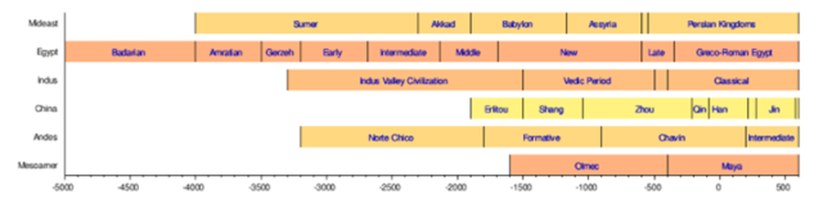
See also:
- Chronology of the ancient Near East
- Cradle of Humankind
- Human history
- Civilization state
- Skara Brae and Barnhouse Settlement 3180 BC.
Archeology including its History
- YouTube Video: Solving Mysteries with Archaeologists!
- YouTube Video: Drone-assisted archeology - hi-tech
- YouTube Video: Archeology – exploring the past with modern technology
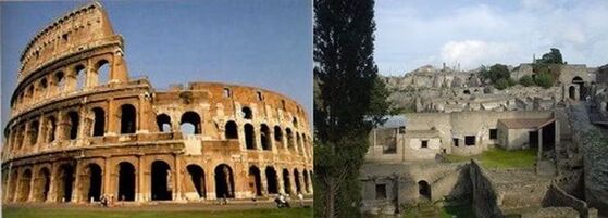
Archaeology, or archeology, is the study of human activity through the recovery and analysis of material culture. The archaeological record consists of artifacts, architecture, biofacts or ecofacts, and cultural landscapes.
Archaeology can be considered both a social science and a branch of the humanities. In North America, archaeology is considered a sub-field of anthropology, while in Europe archaeology is often viewed as either a discipline in its own right or a sub-field of other disciplines.
Archaeologists study human prehistory and history, from the development of the first stone tools at Lomekwi in East Africa 3.3 million years ago up until recent decades. Archaeology as a field is distinct from the discipline of paleontology, the study of fossil remains.
Archaeology is particularly important for learning about prehistoric societies, for whom there may be no written records to study. Prehistory includes over 99% of the human past, from the Paleolithic until the advent of literacy in societies across the world. Archaeology has various goals, which range from understanding culture history to reconstructing past lifeways to documenting and explaining changes in human societies through time.
The discipline involves surveying, excavation and eventually analysis of data collected to learn more about the past. In broad scope, archaeology relies on cross-disciplinary research.
Archeology draws upon the following:
Archaeology developed out of antiquarianism in Europe during the 19th century, and has since become a discipline practiced across the world. Archeology has been used by nation-states to create particular visions of the past.
Since its early development, various specific sub-disciplines of archaeology have developed, including maritime archaeology, feminist archaeology and archaeoastronomy, and numerous different scientific techniques have been developed to aid archaeological investigation.
Nonetheless, today, archaeologists face many problems, such as dealing with pseudoarchaeology, the looting of artifacts, a lack of public interest, and opposition to the excavation of human remains.
Click on any of the following blue hyperlinks for more about Archaeology:
Archaeology can be considered both a social science and a branch of the humanities. In North America, archaeology is considered a sub-field of anthropology, while in Europe archaeology is often viewed as either a discipline in its own right or a sub-field of other disciplines.
Archaeologists study human prehistory and history, from the development of the first stone tools at Lomekwi in East Africa 3.3 million years ago up until recent decades. Archaeology as a field is distinct from the discipline of paleontology, the study of fossil remains.
Archaeology is particularly important for learning about prehistoric societies, for whom there may be no written records to study. Prehistory includes over 99% of the human past, from the Paleolithic until the advent of literacy in societies across the world. Archaeology has various goals, which range from understanding culture history to reconstructing past lifeways to documenting and explaining changes in human societies through time.
The discipline involves surveying, excavation and eventually analysis of data collected to learn more about the past. In broad scope, archaeology relies on cross-disciplinary research.
Archeology draws upon the following:
- anthropology,
- history,
- art history,
- classics,
- ethnology,
- geography,
- geology,
- linguistics,
- semiology,
- physics,
- information sciences,
- chemistry,
- statistics,
- paleoecology,
- paleontology,
- paleozoology,
- paleoethnobotany,
- and paleobotany.
Archaeology developed out of antiquarianism in Europe during the 19th century, and has since become a discipline practiced across the world. Archeology has been used by nation-states to create particular visions of the past.
Since its early development, various specific sub-disciplines of archaeology have developed, including maritime archaeology, feminist archaeology and archaeoastronomy, and numerous different scientific techniques have been developed to aid archaeological investigation.
Nonetheless, today, archaeologists face many problems, such as dealing with pseudoarchaeology, the looting of artifacts, a lack of public interest, and opposition to the excavation of human remains.
Click on any of the following blue hyperlinks for more about Archaeology:
- History
- Purpose
- Methods
- Academic sub-disciplines
- Protection
- Popular views of archaeology
- Current issues and controversy
- See also:
- Archaeobiology
- Archaeogenetics – Application of the techniques of molecular population genetics to the study of the human past
- Archaeology of religion and ritual
- Area of archaeological potential
- Conservation and restoration of archaeological sites
- Chronological dating
- Classical archaeology – Sub-discipline of archeology
- Dump digging
- GIS in archaeology – Aspect of GIS usage
- Harris matrix – Method in archaeology
- Intellectual Property Issues in Cultural Heritage project – Cultural heritage research initiative
- Urban archaeology – Archaeological sub-discipline
- Lists:
- Works related to Archaeology at Wikisource
- Wikimedia Commons has media related to Archaeology.
- Wikiquote has quotations related to: Archaeology
- Wikibooks has more on the topic of: Archaeology
- 400,000 records of archaeological sites and architecture in England
- Archaeolog.org
- Archaeology Daily News
- Council for British Archaeology
- Estudio de Museología Rosario
- Fasti Online – an online database of archaeological sites
- Great Archaeology
- NPS Archeology Program: Visit Archeology (Archeology travel guides)
- Sri Lanka Archaeology
- The Archaeological Institute of America
- The Archaeology Channel
- The Archaeology Data Service – Open access online archive for UK and global archaeology
- The Archaeology Division of the American Anthropological Association
- The Society for American Archaeology
- The World Archaeological Congress
- US Forest Service Volunteer program Passport in Time
- World Archaeology News – weekly update from BBC Radio archaeologist, Win Scutt
- The Italian Archaeological Mission in Uşaklı Höyük
- Comprehensive Database of Archaeological Site Reports in Japan
Anthropology, including its History
- YouTube Video: An introduction to the discipline of Anthropology
- YouTube Video: What Is Cultural Anthropology?
- YouTube Video: Social Anthropology vs Cultural Anthropology: What's the Difference | Off the Shelf 4
Click here for a List of Anthropologists.
Anthropology is the study of various aspects of humans within past and present societies.
Social anthropology and cultural anthropology study the norms and values of societies. Linguistic anthropology studies how language affects social life. Biological or physical anthropology studies the biological development of humans.
Archaeology, which studies past human cultures through investigation of physical evidence, is thought of as a branch of anthropology in the United States, while in Europe, it is viewed as a discipline in its own right, or grouped under other related disciplines such as history.
Click on any of the following blue hyperlinks for more about Anthropology:
- Origin and development of the term
- Through the 19th century
20th and 21st centuries
- Through the 19th century
- Fields
- Key topics by field: sociocultural
- Key topics by field: archaeological and biological
- Organizations including a List of major organizations
- Ethics
- Post–World War II developments
- See also:
- Main article: Outline of anthropology
- Anthropological Index Online (AIO)
- Anthropological science fiction
- Engaged theory
- Ethnology
- Ethnobiology
- Ethology
- Folklore
- Human ethology
- Human evolution
- Human Relations Area Files
- Intangible Cultural Heritage
- Memetics
- Origins of society
- Prehistoric medicine
- Qualitative research
- Sociology
- Theological anthropology, a sub-field of theology
- Philosophical anthropology, a sub-field of philosophy
- Anthropology in Tinbergen's four questions
- Haller, Dieter. "Interviews with German Anthropologists: Video Portal for the History of German Anthropology post 1945". Ruhr-Universität Bochum. Retrieved 22 March 2015.
- "AAANet Home". American Anthropological Association. 2010.
- "Home". European Association of Social Anthropologists. 2015.
- Hagen, Ed (2015). "AAPA". American Association of Physical Anthropologists.
- "AIBR, Revista de Antropología Iberoamericana" (in Spanish). Antropólogos Iberoamericanos en Red. Retrieved 24 March 2015.
- "Home". Human Relations Area Files. Retrieved 24 March 2015.
- "Home". National Association for the Practice of Anthropology. Retrieved 24 March 2015.
- "About". Radical Anthropology Group. Retrieved 24 March 2015.
- "Home". Royal Anthropological Institute. Retrieved 24 March 2015.
- "Home". The Society for Applied Anthropology. Retrieved 24 March 2015.
- "Anthropology". American Museum of Natural History. Retrieved 25 March 2015.
- "Department of Anthropology". Smithsonian National Museum of Natural History. Retrieved 25 March 2015.
- Main article: Outline of anthropology
Paleoanthropology
- YouTube Video: Rick Barker - Paleoanthropology: Early Human Evolution
- YouTube Video: The New Revolution In HUMAN ORIGINS, Dr. Richard Leakey, Leakey Foundation
- YouTube Video: The Fossil Chronicles: Revolutions in Paleoanthropology
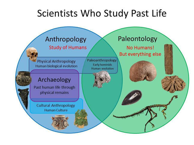
Paleoanthropology or paleo-anthropology is a branch of paleontology and anthropology which seeks to understand the early development of anatomically modern humans, a process known as hominization, through the reconstruction of evolutionary kinship lines within the family Hominidae, working from biological evidence (such as petrified skeletal remains, bone fragments, footprints) and cultural evidence (such as stone tools, artifacts, and settlement localities).
The field draws from and combines primatology, paleontology, biological anthropology, and cultural anthropology. As technologies and methods advance, genetics plays an ever-increasing role, in particular to examine and compare DNA structure as a vital tool of research of the evolutionary kinship lines of related species and genera.
Click on any of the following blue hyperlinks for more about Paleoanthropology:
- Etymology
- Hominoid taxonomies
- History
- Renowned paleoanthropologists
- See also:
- Dawn of Humanity (2015 PBS film)
- Human evolution
- List of human evolution fossils
- The Incredible Human Journey
- Timeline of human evolution
- Fossil Hominids
- Aspects of Paleoanthropology
- Becoming Human: Paleoanthropology, Evolution and Human Origins
- Department of Human Evolution ~ Max Planck Institute, Leipzig
- Human Timeline (Interactive) – Smithsonian, National Museum of Natural History (August 2016).
The Roman Empire (509 BC -- 1453 AD)
including Christianity as the Roman state religion Pictured below: A gallery of images about the Roman Empire
including Christianity as the Roman state religion Pictured below: A gallery of images about the Roman Empire
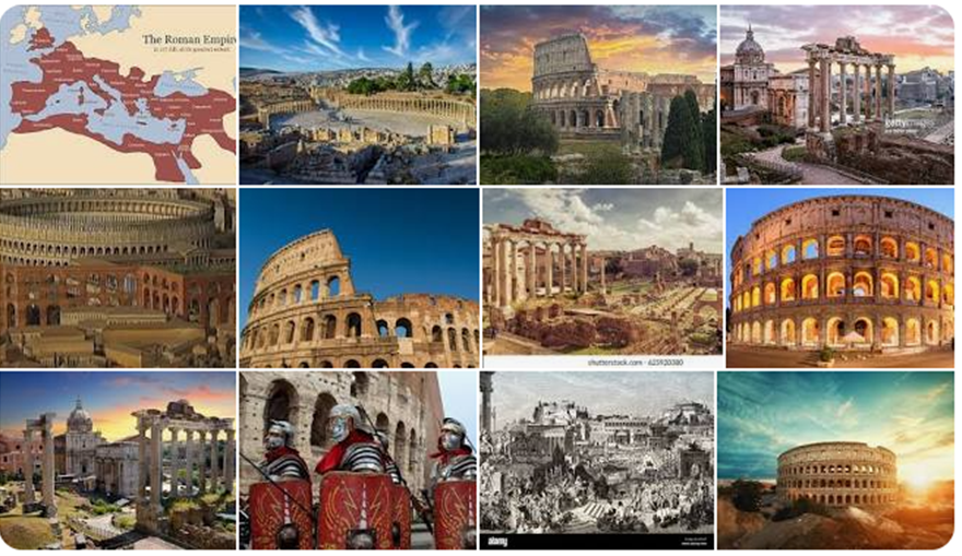
The Roman Empire was the post-Republican period of ancient Rome. As a polity, it included large territorial holdings around the Mediterranean Sea in Europe, North Africa, and Western Asia, and was ruled by emperors.
From the accession of Caesar Augustus as the first Roman emperor to the military anarchy of the 3rd century, it was a Principate with Italia as the metropole of its provinces and the city of Rome as its sole capital.
The Empire was later ruled by multiple emperors who shared control over the Western Roman Empire and the Eastern Roman Empire. The imperial seat moved from Rome to Byzantium and following the collapse of the West in AD 476, it became its sole capital as Constantinople.
The adoption of Christianity as the state church of the Roman Empire in AD 380 and the fall of the Western Roman Empire to Germanic kings conventionally marks the end of classical antiquity and the beginning of the Middle Ages.
Because of these events, along with the prevalence of Greek instead of Latin, some historians distinguish the medieval Roman Empire that remained in the Eastern provinces as the Byzantine Empire.
The predecessor state of the Roman Empire, the Roman Republic, became severely destabilized in civil wars and political conflicts. In the middle of the 1st century BC, Julius Caesar was appointed as dictator perpetuo ("dictator in perpetuity"), and then assassinated in 44 BC.
Civil wars and proscriptions continued, eventually culminating in the victory of Octavian over Mark Antony and Cleopatra at the Battle of Actium in 31 BC. The following year, Octavian conquered the Ptolemaic Kingdom in Egypt, ending the Hellenistic period that had begun with the 4th century BC conquests of Alexander the Great. Octavian's power became unassailable and the Roman Senate granted him overarching power (imperium) and the new title of Augustus, making him the first Roman emperor.
The vast Roman territories were organized in senatorial and imperial provinces except Italy, which continued to serve as a metropole.
The first two centuries of the Roman Empire saw a period of unprecedented stability and prosperity known as the Pax Romana (lit. 'Roman Peace'). Rome reached its greatest territorial expanse during the reign of Trajan (AD 98–117); a period of increasing trouble and decline began with the reign of Commodus (177–192).
In the 3rd century, the Empire underwent a crisis that threatened its existence, as the Gallic and Palmyrene Empires broke away from the Roman state, and a series of short-lived emperors, often from the legions, led the Empire. It was reunified under Aurelian (r. 270–275). To stabilize it, Diocletian set up two different imperial courts in the Greek East and Latin West in 286; Christians rose to positions of power in the 4th century following the Edict of Milan of 313.
Shortly after, the Migration Period, involving large invasions by Germanic peoples and by the Huns of Attila, led to the decline of the Western Roman Empire. With the fall of Ravenna to the Germanic Herulians and the deposition of Romulus Augustus in AD 476 by Odoacer, the Western Roman Empire finally collapsed; the Eastern Roman emperor Zeno formally abolished it in AD 480.
The Eastern Roman Empire survived for another millennium, until Constantinople fell in 1453 to the Ottoman Turks under Mehmed II.
Due to the Roman Empire's vast extent and long endurance, the institutions and culture of Rome had a profound and lasting influence on the development of the following:
The Latin language of the Romans evolved into the Romance languages of the medieval and modern world, while Medieval Greek became the language of the Eastern Roman Empire. The Empire's adoption of Christianity led to the formation of medieval Christendom. Roman and Greek art had a profound impact on the Italian Renaissance.
Rome's architectural tradition served as the basis for Romanesque, Renaissance and Neoclassical architecture, and also had a strong influence on Islamic architecture. The rediscovery of Greek and Roman science and technology (which also formed the basis for Islamic science) in Medieval Europe led to the Scientific Renaissance and Scientific Revolution.
The corpus of Roman law has its descendants in many modern legal systems of the world, such as the Napoleonic Code of France, while Rome's republican institutions have left an enduring legacy, influencing the Italian city-state republics of the medieval period, as well as the early United States and other modern democratic republics.
Click on any blue hyperlink below to be taken to that topic:
Christianity as the Roman state religion:
Christianity became the official religion of the Roman Empire when Emperor Theodosius I issued the Edict of Thessalonica in 380, which recognized the catholic orthodoxy of Nicene Christians in the Great Church as the Roman Empire's state religion.
Most historians refer to the Nicene church associated with emperors in a variety of ways: as the catholic church, the orthodox church, the imperial church, the imperial Roman church, or the Byzantine church, although some of those terms are also used for wider communions extending outside the Roman Empire.
The Eastern Orthodox Church, Oriental Orthodoxy, and the Catholic Church all claim to stand in continuity from the Nicene church to which Theodosius granted recognition.
Earlier in the 4th century, following the Diocletianic Persecution of 303–313 and the Donatist controversy that arose in consequence, Constantine the Great had convened councils of bishops to define the orthodoxy of the Christian faith and to expand on earlier Christian councils.
A series of ecumenical councils convened by successive Roman emperors met during the 4th and the 5th centuries, but Christianity continued to suffer rifts and schisms surrounding the theological and christological doctrines of Arianism, Nestorianism, and Miaphysitism.
In the 5th century, the Western Roman Empire decayed as a polity; invaders sacked Rome in 410 and in 455, and Odoacer, an Arian barbarian warlord, forced Romulus Augustus, the last nominal Western Emperor, to abdicate in 476.
However, apart from the aforementioned schisms, the church as an institution persisted in communion, if not without tension, between the East and West.
In the 6th century, the Byzantine armies of the Byzantine Emperor Justinian I recovered Italy and other regions of the Western Mediterranean shore. The Byzantine Empire soon lost most of these gains, but it held Rome, as part of the Exarchate of Ravenna, until 751, a period known in church history as the Byzantine Papacy.
The early Muslim conquests of the 7th–9th centuries would begin a process of converting most of the then-Christian world in the Levant, Middle East, North Africa, regions of Southern Italy and the Iberian Peninsula to Islam, severely restricting the reach both of the Byzantine Empire and of its church.
Christian missionary activity directed from the capital of Constantinople did not lead to a lasting expansion of the formal link between the church and the Byzantine emperor, since areas outside the Byzantine Empire's political and military control set up their own distinct churches, as in the case of Bulgaria in 919.
Justinian I, who became emperor in 527, recognized the patriarchs of the following:
However, Justinian claimed "the right and duty of regulating by his laws the minutest details of worship and discipline, and also of dictating the theological opinions to be held in the Church".
In Justinian's day, the Christian church was not entirely under the emperor's control even in the East: the Oriental Orthodox Churches had seceded, having rejected the Council of Chalcedon in 451, and called the adherents of the imperially-recognized church "Melkites", from Syriac malkâniya ("imperial").
In Western Europe, Christianity was mostly subject to the laws and customs of nations that owed no allegiance to the emperor in Constantinople. While Eastern-born popes appointed or at least confirmed by the emperor continued to be loyal to him as their political lord, they refused to accept his authority in religious matters, or the authority of such a council as the imperially convoked Council of Hieria of 754. Pope Gregory III (731–741) was the last Bishop of Rome to ask the Byzantine ruler to ratify his election.
With the crowning of Charlemagne by Pope Leo III on 25 December 800 as Imperator Romanorum, the political split between East and West became irrevocable.
Spiritually, Chalcedonian Christianity persisted, at least in theory, as a unified entity until the Great Schism and its formal division with the mutual excommunication in 1054 of Rome and Constantinople. The empire finally collapsed with the Fall of Constantinople to the Islamic Ottoman Turks in 1453.
The obliteration of the empire's boundaries by Germanic peoples and an outburst of missionary activity among these peoples, who had no direct links with the empire, and among Pictic and Celtic peoples who had never been part of the Roman Empire, fostered the idea of a universal church free from association with a particular state.
On the contrary, "in the East Roman or Byzantine view, when the Roman Empire became Christian, the perfect world order willed by God had been achieved: one universal empire was sovereign, and coterminous with it was the one universal church"; and the church came, by the time of the demise of the Byzantine Empire in 1453, to merge psychologically with it to the extent that its bishops had difficulty in thinking of Nicene Christianity without an emperor.
The legacy of the idea of a universal church carries on in today's Catholic Church, Eastern Orthodox Church, Oriental Orthodox Churches, and the Church of the East. Many other churches, such as the Anglican Communion, claim succession to this universal church.
Click on any of the following blue hyperlinks for more about Christianity as the Roman state religion:
From the accession of Caesar Augustus as the first Roman emperor to the military anarchy of the 3rd century, it was a Principate with Italia as the metropole of its provinces and the city of Rome as its sole capital.
The Empire was later ruled by multiple emperors who shared control over the Western Roman Empire and the Eastern Roman Empire. The imperial seat moved from Rome to Byzantium and following the collapse of the West in AD 476, it became its sole capital as Constantinople.
The adoption of Christianity as the state church of the Roman Empire in AD 380 and the fall of the Western Roman Empire to Germanic kings conventionally marks the end of classical antiquity and the beginning of the Middle Ages.
Because of these events, along with the prevalence of Greek instead of Latin, some historians distinguish the medieval Roman Empire that remained in the Eastern provinces as the Byzantine Empire.
The predecessor state of the Roman Empire, the Roman Republic, became severely destabilized in civil wars and political conflicts. In the middle of the 1st century BC, Julius Caesar was appointed as dictator perpetuo ("dictator in perpetuity"), and then assassinated in 44 BC.
Civil wars and proscriptions continued, eventually culminating in the victory of Octavian over Mark Antony and Cleopatra at the Battle of Actium in 31 BC. The following year, Octavian conquered the Ptolemaic Kingdom in Egypt, ending the Hellenistic period that had begun with the 4th century BC conquests of Alexander the Great. Octavian's power became unassailable and the Roman Senate granted him overarching power (imperium) and the new title of Augustus, making him the first Roman emperor.
The vast Roman territories were organized in senatorial and imperial provinces except Italy, which continued to serve as a metropole.
The first two centuries of the Roman Empire saw a period of unprecedented stability and prosperity known as the Pax Romana (lit. 'Roman Peace'). Rome reached its greatest territorial expanse during the reign of Trajan (AD 98–117); a period of increasing trouble and decline began with the reign of Commodus (177–192).
In the 3rd century, the Empire underwent a crisis that threatened its existence, as the Gallic and Palmyrene Empires broke away from the Roman state, and a series of short-lived emperors, often from the legions, led the Empire. It was reunified under Aurelian (r. 270–275). To stabilize it, Diocletian set up two different imperial courts in the Greek East and Latin West in 286; Christians rose to positions of power in the 4th century following the Edict of Milan of 313.
Shortly after, the Migration Period, involving large invasions by Germanic peoples and by the Huns of Attila, led to the decline of the Western Roman Empire. With the fall of Ravenna to the Germanic Herulians and the deposition of Romulus Augustus in AD 476 by Odoacer, the Western Roman Empire finally collapsed; the Eastern Roman emperor Zeno formally abolished it in AD 480.
The Eastern Roman Empire survived for another millennium, until Constantinople fell in 1453 to the Ottoman Turks under Mehmed II.
Due to the Roman Empire's vast extent and long endurance, the institutions and culture of Rome had a profound and lasting influence on the development of the following:
- language,
- religion,
- art,
- architecture,
- literature,
- philosophy,
- law,
- and forms of government in the territory it governed.
The Latin language of the Romans evolved into the Romance languages of the medieval and modern world, while Medieval Greek became the language of the Eastern Roman Empire. The Empire's adoption of Christianity led to the formation of medieval Christendom. Roman and Greek art had a profound impact on the Italian Renaissance.
Rome's architectural tradition served as the basis for Romanesque, Renaissance and Neoclassical architecture, and also had a strong influence on Islamic architecture. The rediscovery of Greek and Roman science and technology (which also formed the basis for Islamic science) in Medieval Europe led to the Scientific Renaissance and Scientific Revolution.
The corpus of Roman law has its descendants in many modern legal systems of the world, such as the Napoleonic Code of France, while Rome's republican institutions have left an enduring legacy, influencing the Italian city-state republics of the medieval period, as well as the early United States and other modern democratic republics.
Click on any blue hyperlink below to be taken to that topic:
- History
- Geography and demography
- Languages
- Society
- Government and military
- Economy
- Architecture and engineering
- Health and disease
- Daily life
- Arts
- Literacy, books, and education
- See also:
- Legacy of the Roman Empire
- Outline of ancient Rome
- Fall of the Western Roman Empire
- List of political systems in France
- List of Roman dynasties
- Daqin ("Great Qin"), the ancient Chinese name for the Roman Empire; see also Sino-Roman relations
- Imperial Italy
- Byzantine Empire under the Justinian dynasty
Christianity as the Roman state religion:
Christianity became the official religion of the Roman Empire when Emperor Theodosius I issued the Edict of Thessalonica in 380, which recognized the catholic orthodoxy of Nicene Christians in the Great Church as the Roman Empire's state religion.
Most historians refer to the Nicene church associated with emperors in a variety of ways: as the catholic church, the orthodox church, the imperial church, the imperial Roman church, or the Byzantine church, although some of those terms are also used for wider communions extending outside the Roman Empire.
The Eastern Orthodox Church, Oriental Orthodoxy, and the Catholic Church all claim to stand in continuity from the Nicene church to which Theodosius granted recognition.
Earlier in the 4th century, following the Diocletianic Persecution of 303–313 and the Donatist controversy that arose in consequence, Constantine the Great had convened councils of bishops to define the orthodoxy of the Christian faith and to expand on earlier Christian councils.
A series of ecumenical councils convened by successive Roman emperors met during the 4th and the 5th centuries, but Christianity continued to suffer rifts and schisms surrounding the theological and christological doctrines of Arianism, Nestorianism, and Miaphysitism.
In the 5th century, the Western Roman Empire decayed as a polity; invaders sacked Rome in 410 and in 455, and Odoacer, an Arian barbarian warlord, forced Romulus Augustus, the last nominal Western Emperor, to abdicate in 476.
However, apart from the aforementioned schisms, the church as an institution persisted in communion, if not without tension, between the East and West.
In the 6th century, the Byzantine armies of the Byzantine Emperor Justinian I recovered Italy and other regions of the Western Mediterranean shore. The Byzantine Empire soon lost most of these gains, but it held Rome, as part of the Exarchate of Ravenna, until 751, a period known in church history as the Byzantine Papacy.
The early Muslim conquests of the 7th–9th centuries would begin a process of converting most of the then-Christian world in the Levant, Middle East, North Africa, regions of Southern Italy and the Iberian Peninsula to Islam, severely restricting the reach both of the Byzantine Empire and of its church.
Christian missionary activity directed from the capital of Constantinople did not lead to a lasting expansion of the formal link between the church and the Byzantine emperor, since areas outside the Byzantine Empire's political and military control set up their own distinct churches, as in the case of Bulgaria in 919.
Justinian I, who became emperor in 527, recognized the patriarchs of the following:
- Rome,
- Constantinople,
- Alexandria,
- Antioch,
- and Jerusalem
However, Justinian claimed "the right and duty of regulating by his laws the minutest details of worship and discipline, and also of dictating the theological opinions to be held in the Church".
In Justinian's day, the Christian church was not entirely under the emperor's control even in the East: the Oriental Orthodox Churches had seceded, having rejected the Council of Chalcedon in 451, and called the adherents of the imperially-recognized church "Melkites", from Syriac malkâniya ("imperial").
In Western Europe, Christianity was mostly subject to the laws and customs of nations that owed no allegiance to the emperor in Constantinople. While Eastern-born popes appointed or at least confirmed by the emperor continued to be loyal to him as their political lord, they refused to accept his authority in religious matters, or the authority of such a council as the imperially convoked Council of Hieria of 754. Pope Gregory III (731–741) was the last Bishop of Rome to ask the Byzantine ruler to ratify his election.
With the crowning of Charlemagne by Pope Leo III on 25 December 800 as Imperator Romanorum, the political split between East and West became irrevocable.
Spiritually, Chalcedonian Christianity persisted, at least in theory, as a unified entity until the Great Schism and its formal division with the mutual excommunication in 1054 of Rome and Constantinople. The empire finally collapsed with the Fall of Constantinople to the Islamic Ottoman Turks in 1453.
The obliteration of the empire's boundaries by Germanic peoples and an outburst of missionary activity among these peoples, who had no direct links with the empire, and among Pictic and Celtic peoples who had never been part of the Roman Empire, fostered the idea of a universal church free from association with a particular state.
On the contrary, "in the East Roman or Byzantine view, when the Roman Empire became Christian, the perfect world order willed by God had been achieved: one universal empire was sovereign, and coterminous with it was the one universal church"; and the church came, by the time of the demise of the Byzantine Empire in 1453, to merge psychologically with it to the extent that its bishops had difficulty in thinking of Nicene Christianity without an emperor.
The legacy of the idea of a universal church carries on in today's Catholic Church, Eastern Orthodox Church, Oriental Orthodox Churches, and the Church of the East. Many other churches, such as the Anglican Communion, claim succession to this universal church.
Click on any of the following blue hyperlinks for more about Christianity as the Roman state religion: